
From space to oceans: how SWOT is transforming our understanding of water on Earth
Since its launch in , the Surface Water and Ocean Topography (SWOT) mission has provided unprecedented insights into one of Earth's most important resources: water. Led by NASA and France's space agency (CNES) and supported by the Canadian Space Agency (CSA) and the UK Space Agency, the mission has transformed how scientists monitor oceans, lakes, and rivers, revealing how water moves and changes over time in remarkable detail. They can even study remote places that were once difficult to reach, such as the Arctic.
The mission is especially important for Canada. The country has three ocean coastlines and about 20% of the world's surface freshwater. These vast waters are essential to both our environment and our economy.

Sea surface water mosaic over Canada. The SWOT satellite maps ocean surface height in 2D, scanning a 120 km-wide swath to capture fine details of the ocean's shape. (Credit: CSA, contains SWOT data and Esri Basemap processed ASL)
A mission powered by innovation
At the heart of SWOT is its main instrument: the Ka-band Radar Interferometer (KaRIn), to which Canada provided critical and specialized components. This instrument uses advanced radar technology to measure water surface elevation with incredible precision. This helps scientists map almost all surface water on the planet and track water elevations.

Satellite image over Baffin Bay. The SWOT satellite showed ability to monitor sea ice, a key driver of ocean circulation that Arctic warming disrupts, affecting heat, oxygen, and nutrient flow. (Credit: CSA, contains SWOT data and Esri Basemap processed by ASL)
Recent discoveries shaping our understanding of water
Detailed water data is essential for making critical decisions. It supports safer shipping routes, improves flood monitoring and helps guide hydropower development. It also contributes to climate change adaptation and the protection of marine ecosystems.
Already, the mission has delivered remarkable insights across oceans and inland waters. Recent findings include:
- Revealing the power of ocean swell: SWOT's data shows how storm waves can become very steep, sometimes reaching up to 20 metres. This helps improve safety along coasts.
- Detecting seismic signals: The satellite can detect large waves caused by landslides. This helps identify extreme events associated with climate change, particularly in the Arctic.
- Mapping fine-scale seafloor features: Satellite data shows seamounts and deep-sea large structures in detail. This helps us better understand marine geology and ocean circulation.
- Advancing river monitoring systems: High-resolution data like SWOT's enhances the ability to monitor rivers and better understand hydrological processes.
- Tracking changes in global river size: Satellite data combined with climate models show where rivers are growing or shrinking. This gives new insights into environmental changes.

Satellite image of the Manicouagan Reservoir. The SWOT satellite tracks its seasonal changes – and other northern reservoirs – to help monitor water levels and climate impacts on freshwater. (Credit: CSA, contains SWOT and Sentinel-2 data, Esri Basemap processed by H2O Geomatics)
A decade of Canadian scientific leadership
More than 2,400 researchers from over 45 countries have worked on science related to the SWOT mission. And a big part of this success comes from over 10 years of support from the CSA. This long-term commitment has helped build a collaborative research community in Canada. It has brought together experts from 14 institutions across the country.
The impact is clear: Canadian researchers have published over 60 scientific papers, accounting for roughly 10% of all research produced by the mission. This sustained contribution supports not only the mission's success but also its lasting impact. It is helping grow knowledge that benefits Canada and the world.

Satellite image of the St. Lawrence Seaway near Montreal. The SWOT satellite monitors surface water elevation, improving dam regulation and navigation safety. (Credit: CSA, contains SWOT and Sentinel-2 data, Esri Basemap processed by H2O Geomatics)
A global mission with lasting impact
The mission's impact will last long after its operational lifetime. Its data will continue to support climate research and improve water management. This will help us adapt to environmental change for years to come. This is a major step forward in Earth observation.
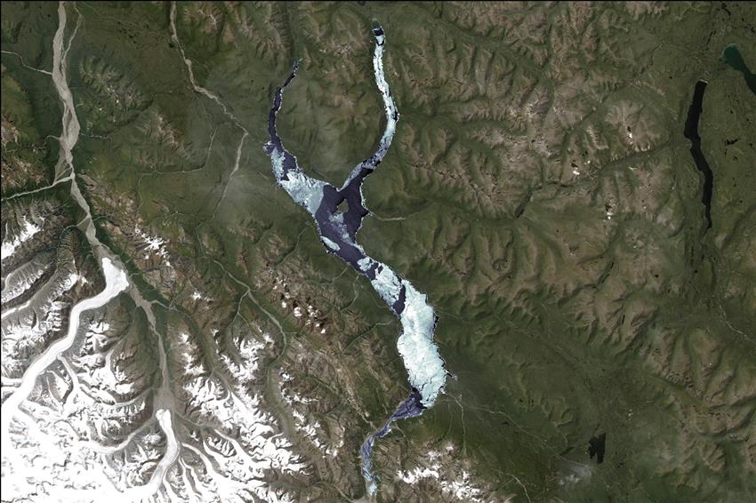
Satellite image capturing the melting ice on Kluane Lake in Yukon. Although the SWOT satellite was mainly developed to track variations in water surface elevation, its radar data can also detect ice. This enables a broader range of research applications. (Credit: CSA, contains SWOT data and Esri Basemap processed by ASL)
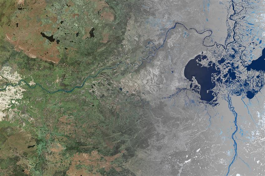
Satellite image of the Peace–Athabasca Delta, one of the largest inland freshwater deltas in the world. This landscape is composed of interconnected rivers, lakes, channels, marshes, and grasslands, forming a rich ecosystem. (Credit: CSA, contains SWOT data and Bing Basemap processed by ASL)
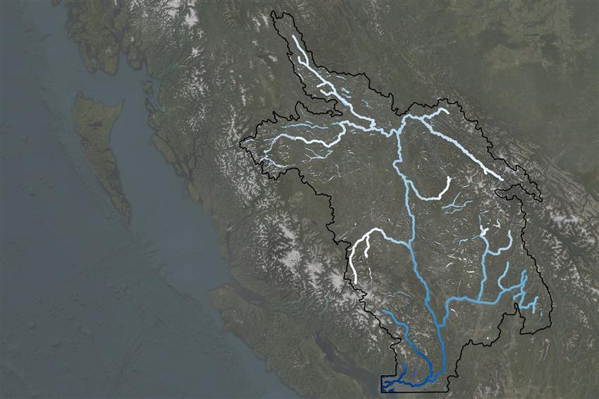
Satellite image of the Fraser River Basin. The SWOT satellite measures water elevations, providing key insights for public safety, ecosystems, and water resource management across much of British Columbia. (Credit: CSA, contains SWOT data and Esri Basemap processed by ASL)