
The Surface Water and Ocean Topography (SWOT) mission

- Launch:
- Mission status: Active
- Mission duration: 3 years with possibility to extend
An international mission
The SWOT mission is providing us with new and detailed information on one of the most important resources we share – water.
Led by NASA and France's space agency (CNES), in collaboration with the CSA and the UK Space Agency, SWOT surveys 90% of Earth's surface water, measuring changes in water surface elevation for lakes, rivers, reservoirs, and oceans over time.
By using innovative technology, SWOT measures ocean features at spatial scales up to 10 times smaller than previous technologies can. These precise measurements provide the scientific community with a better understanding of the dynamics of the world's oceans and terrestrial surface water, allowing them to address important global issues like climate change and improve our management of water as a strategic resource.
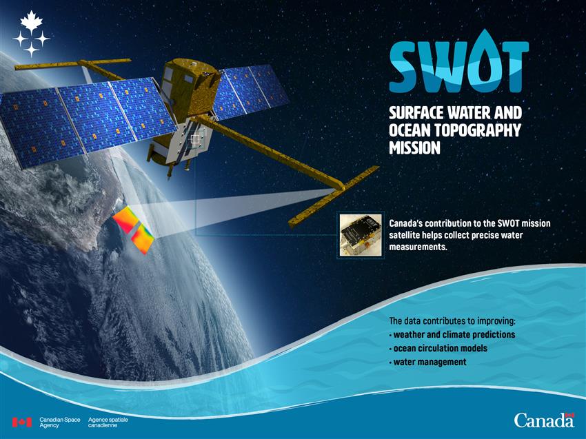
2017-01-16 – This animation shows the SWOT mission satellite collecting precise water level measurements. (Credits: NASA, JPL-Caltech)
Canada's contribution
Canada's participation in this mission brings significant benefits: it builds on the strength and expertise of our industry and its economic growth; it also represents an important gain in scientific knowledge.
Technology
The Canadian Space Agency (CSA) accepted NASA's invitation to participate in the SWOT mission by providing a key component of the wide-swath radar instrument – a set of extended interaction klystrons (EIKs). This is a modest contribution to this major US$1.2B investment but nevertheless crucial, as the EIKs amplify the power needed by the wide-swath instrument to generate the microwave pulses that are used to measure water surface elevation.
Communications & Power Industries Canada Inc. is world-renowned for its expertise in building this sophisticated device, as no other firms have a proven record of building and flying space-grade EIKs.
Text version of the infographic SWOT - Surface Water and Topography Mission
SWOT - Surface Water and Topography Mission infographic. (Credit: CSA)
Science
Through this partnership, free access to SWOT data can now improve many water-related services in Canada, including flood and water level monitoring. This effort will help with implementing sustainable water management policies.

Infographic presenting elements to be studied by Canadian scientists with SWOT mission data. (Credit: CSA)
The SWOT international science team, including Canadian scientists from Environment and Climate Change Canada and Fisheries and Oceans Canada, is pursuing SWOT mission objectives and desired outcomes within two main areas of research, hydrology and oceanography, to enhance our understanding of:
- the water cycle across the country
- sea level variations in Canadian waters
Hydrology

| Mission objectives | Desired outcomes |
|---|---|
|
|
Oceanography

| Mission objectives | Desired outcomes |
|---|---|
|
|
Benefits to Canadians
The information received is greatly improving the delivery of services related to key national priorities related to water, such as marine safety and security, water management, responsible resource development, fisheries, climate change adaptation, marine transportation and sustainable development in the North. For example:
Marine safety and security

Example: Support the Canadian Coast Guard's search and rescue operations at sea by providing better information on water levelcurrents to more accurately forecast the water surface currents and the positions of drifting objects, ice and icebergs, oil spills or other potential contaminants.
Water management
Example: Environment and Climate Change Canada, in cooperation with provincial and territorial partners, monitors water level and flow at approximately 2500 key locations on lakes and rivers in Canada (Water Survey of Canada). Due to the complexity and cost of operating ground-based hydrometric monitoring gauges, especially in remote regions, this represents only a small fraction of the total number of lakes and rivers in Canada. SWOT provides coverage of most lakes and rivers up to four times every three weeks, including northern Canada, where very few measurements were taken previously. This global inventory of Canadian waters serves to improve our water management and assist in prediction of floods and drought.
Responsible resource development

Example: Measurements provided by SWOT benefit user communities such as structural engineers who use hydrometric data to optimize the design of various types of structures such as bridges, culverts, pipeline crossings, dams, reservoirs, hydroelectric plants, dykes and other water-related structures.
Conservation and protection

Example: Support sustainable management of fish habitat by providing relevant information derived from measuring water surface elevation of the oceans and freshwater water bodies such as major rivers and lakes. For example, these satellite-based measurements enable monitoring of streamflow in rivers and water storage in lakes, which are important parameters for fish migration and the availability of spawning and rearing habitat.
Marine transportation
Example: Provide optimized shipping routes based on accurate knowledge of marine currents, waves and water levels. These optimized shipping routes have demonstrated up to 8% savings on time and fuel for crossing the Atlantic, which represents a significant efficiency improvement for marine operators and reduces the risk of accidents.
Sustainable development in the North

Example: SWOT's high-valued data assists decision makers to better monitor the effects of climate change happening in the North. Information provided to the government on water quantity supports biodiversity and habitat assessments, as well as environmental prediction activities.
Participating universities
- Université de Sherbrooke
- University of Toronto
- McGill University
- Dalhousie University
- Wilfrid Laurier University
- Université Laval
- Guelph University
- Concordia University
- Université du Québec à Rimouski
- University of Victoria