
Using satellites to protect and navigate Canada's waters

Essential to all forms of life, water is one of our most valuable resources, but also one of the most heavily exploited. Given the fragility of this resource, a number of satellites are providing information to help us protect it.
Which satellites are used to observe our waters and oceans?
- RADARSAT Constellation Mission and RADARSAT-2: To facilitate maritime surveillance, ice monitoring, environmental monitoring, disaster management, resource management and mapping in Canada and around the world.
- SMOS: To map sea surface salinity, monitor soil moisture on a global scale, better understand the water cycle, and map snow- and ice-covered areas.
- SWOT (in development): To observe ocean surfaces and measure how lakes, rivers, reservoirs and oceans are changing over time.
- M3MSat: To improve Canada's ability to locate ships and manage marine traffic.
Why use satellites to observe waters and oceans?
Ice and iceberg monitoring
Canada is a northern country. Pack ice and sea ice—indicators of environmental health—pose year-round challenges for navigators.

Image of an Iceberg reflecting in the water.
Monitoring ice from space provides a precise picture of navigation conditions and Arctic ecosystems, which enables Canada to:
- establish safe navigable waters;
- ensure the delivery of vital supplies to isolated communities, offshore platforms and ocean research stations;
- provide reliable data on the impacts of climate change.
RADARSAT satellites
What are they used for?
Born out of the need to effectively monitor icy waters, Canada's RADARSAT satellites have been collecting data day and night via radar, regardless of cloud cover conditions, since the launch of RADARSAT-1 in . These characteristics make the satellites ideal for observing marine and coastal environments.
RADARSAT images can be used to identify various types of ice and to provide daily mapping. They are also used for the surveillance of rivers and the analysis of ice cover.
The RADARSAT Constellation Mission (RCM) provides us with even more precise data on ice quantity, density and strength to help us better understand the ice formation cycle.
Finding and observing water sources
Canada is bordered by three oceans, and eight major rivers flow through it. With its Great Lakes and its millions of lakes and rivers, our country has impressive freshwater reserves.
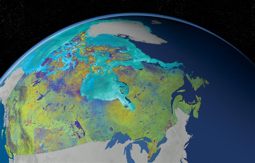
This is a mosaic of Canada made from 121 images captured by Canadian satellite RADARSAT-2. (Credit: RADARSAT-2 Data and Products © MacDonald, Dettwiler and Associates Ltd., . In collaboration with the Canadian Ice Service. All Rights Reserved. RADARSAT is an official mark of the Canadian Space Agency)
Not all countries are so fortunate. Over a billion people around the world do not have access to drinking water.
Satellite data support our analyses so that we can protect our resources effectively and better understand the effects of climate change on the water cycle.
RADARSAT satellites
What are they used for?
RADARSAT-2 and the RCM distinguish the various types of surface, whether rough like sand or smooth like a calm body of water.
RADARSAT images are used to:
- map coastal areas and identify wetlands or submerged areas;
- locate and measure surface and ground water bodies, soil moisture and snow depth.
SMOS
What is it used for?
SMOS maps the salinity of oceans as well as snow- and ice-covered areas, in addition to measuring soil moisture.
With data from this satellite, we can better understand:
- the water cycle and our climate systems;
- the effect of human activity on Earth's natural processes.
Monitoring wildlife, coastlines and oceans
Our oceans, our waterways and their shorelines are ecosystems that support abundant fish populations and that are home to many other living organisms year round.

Cape St. Mary's Ecological Reserve in Newfoundland. Note the colony of northern gannets on the rock face.
RADARSAT Constellation
What is it used for?
By surveying the various ecosystems of Canada and the world, the RCM produces radar images that enable us to:
- map coastal erosion and prepare a comprehensive inventory of wetlands;
- assess the impact of human activity and climate change on coastlines;
- rapidly identify, in combination with signals from the automatic identification system (AIS), the vessels navigating our waters and to detect those engaging in illegal fishing or causing oil spills.
SWOT
What will it be used for?
SWOT will provide complete coverage of most lakes and rivers around the world, including those in Canada's North.
The satellite will take an inventory of Canadian waters to:
- improve how we manage our water resources;
- make it easier to predict floods and droughts;
- support Canadian fishing activities by monitoring the migratory characteristics of commercial species. Fishers will be able to make reliable forecasts of fish locations using ultra-precise data on oceanic gyres in areas with major fish stocks.
Guiding vessels
In recent decades, marine shipping, fishing activities, and oil and gas exploration have been on the rise. Navigating through ice adds to the complexity of such activities.
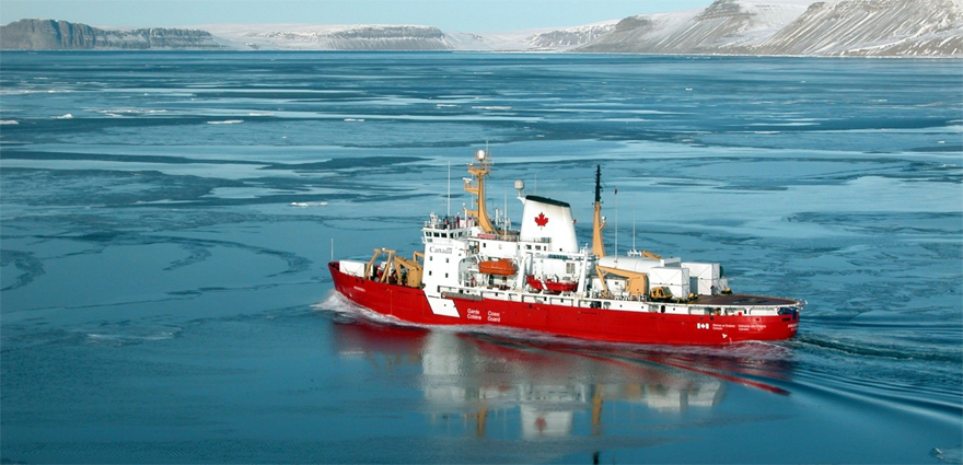
An icebreaker opens up a passage in Canada's northern waters. (Credit: Canadian Coast Guard)
In recent decades, marine shipping, fishing activities, and oil and gas exploration have been on the rise. Navigating through ice adds to the complexity of such activities.
Canada provides radar data for estimating the thickness of sea ice and the location of ocean surface wave fields, but also for detecting vessels navigating through them. Thanks in part to satellite data, coastal authorities can ensure safety at sea and monitor commercial shipping traffic. For example, RADARSAT-2 images helped Crystal Serenity, the largest cruise ship to have sailed the Northwest Passage, safely make its way through icy waters in .
Capturing identification signals from vessels
At sea, ships use an automatic identification system (AIS) that transmits key information on the vessel's identity, its direction and its cruising speed. The AIS signals are used to detect other ships and avoid collisions at sea.
This technology, onboard the M3MSat satellite, has revolutionized the way we monitor and manage the safety of vessels at sea, because we now have a better overview of marine traffic.
The three satellites of the RADARSAT Constellation Mission are also equipped with AIS technology.
Navigating sea ice to deliver supplies

Credit: Michael Stokes
Michael Stokes is a ship's captain who mostly works in the Arctic. He brings food and supplies to a remote mining community. He is one of the few captains operating in the region. RADARSAT data is essential to his work. The ship he navigates is 40 years old and is the oldest in the fleet. That means he has to be extra careful to avoid getting jammed in sea ice, which risks damaging the ship. RADARSAT data provides Michael with the details that he needs to make navigation decisions to keep his crew safe and ensure the supplies are delivered. Read Michael's full story.
SWOT
This satellite's innovative technology, which includes the ability to provide data on sea currents, will make it possible to suggest optimal navigation routes. Navigators may also be able to cut their travel time and fuel costs by 8% when crossing the Atlantic.
The mission may also support the Canadian Coast Guard's search and rescue operations at sea by providing better information on currents to more accurately forecast the positions of drifting objects, ice and icebergs.
Finally, SWOT will also facilitate activities in Canada's fishing industry and help us better understand the water cycle and better manage our water resources.
This animation shows the SWOT satellite collecting precise measurements of certain water surfaces. (Credits: NASA, JPL-Caltech)
Helping with rescues
When the power of the sea is unleashed, it often threatens the safety of entire communities.
To better coordinate their rescue operations, authorities around the world often turn to satellites. The 17 signatories to the International Charter Space and Major Disasters, including Canada, work together and share their satellite data in a timely manner to assist people and protect infrastructure.

Rescue exercise with a Canadian Coast Guard helicopter and ship. (Credit: Canadian Coast Guard)
RADARSAT satellites
What are they used for?
Around the clock and through the clouds, RADARSAT-2 uses its radar to detect the characteristics of hurricanes and tropical storms, as well as their effects on the environment.
Emergency response teams on the ground use this valuable information to make informed decisions and effectively plan their response.
RADARSAT Constellation satellites strengthen Canada's ability to monitor hurricanes, assess the extent of flooding or predict flash floods.