
The Floe of Time
Credit: Inuvialuit Regional Corporation, Hotspur Studio, Arctic Institute of North America, and Polar View. Contains modified Copernicus Sentinel-2 data () processed by ESA
- Location: Inuvialuit Settlement Region, Northwest Territories
- Company: Polar View
The Arctic from space allures with its sensual shapes and whirling movement. A "secret ministry of frost," as English poet Samuel Taylor Coleridge might describe it: we recognize something so familiar, yet so foreign, as another heavenly body might appear to us – views from space shifting our unconscious perspective with their odd beauty.
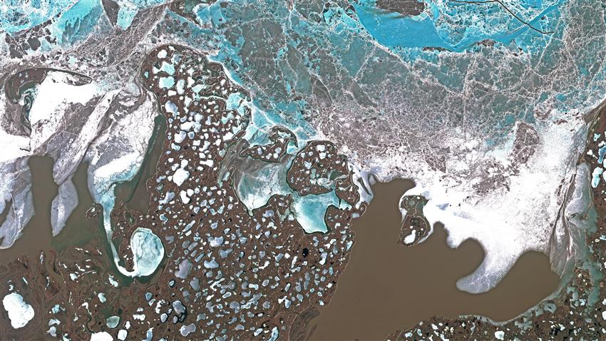
This Sentinel-2 image of , covers a part of the Mackenzie River delta where the brown, sediment-rich waters of the East Arm meet the still ice-covered Arctic Ocean. The area is part of the Inuvialuit Settlement Region. Tuktoyaktuk and the Pingo Canadian Landmark lie at the bottom right of the image. The Inuvialuit (meaning "the real people") migrated to the area from the Bering Sea region some 800 years ago. Today, many of the Inuvialuit reside in the communities of Aklavik, Inuvik, Paulatuk, Sachs Harbour, Tuktoyaktuk and Ulukhaktok.
The geomorphology of the area is characterized by the interaction of river, ocean, permafrost, and ice floes. Ice wedge polygons, retrogressive thaw slumps, pingos and shallow lakes are examples of the region's landforms. The landscape is always in motion, but the rate of change is increasing as climate change results in less sea ice, the thawing of permafrost, and thereby, increased coastal erosion.