
Maritime Monitoring and Messaging Microsatellite (M3MSat)

Launch:
Status: Inactive
Mission accomplished!
Canada's Maritime Monitoring and Messaging (M3MSat) Microsatellite mission successfully demonstrated ship detection, maritime traffic and satellite health and safety technologies. The satellite delivered high-quality data over the course of nearly nine years!
On , M3MSat naturally re-entered Earth's atmosphere, marking the end of its mission.
The M3MSat mission was designed to test:
- innovative technologies for ship detection and marine traffic management before being deployed on full-scale space missions
- a device to improve the way we monitor the health and safety of satellites.
Collaboration
M3MSat was a great example of collaboration between government, industry and academia to drive innovation in Canada's space sector.
The Canadian Space Agency (CSA) was responsible for two instruments:
- the Low Data Rate System (LDRS)
- the Dielectric Deep Charge Monitor (DDCM)
Defence Research and Development Canada (DRDC) was responsible for the Automatic Identification System (AIS).
The satellite was built by Ontario-based company COM DEV International (now Honeywell Canada), with support from the University of Toronto Institute for Aerospace Studies and the University of Waterloo.
2016-06-21 – Canada's Maritime Monitoring and Messaging Microsatellite (M3MSat) was launched successfully by the Indian Space Research Organisation, from Sriharikota, India. (Credit: Door Darshan (DD))
A successful technology demonstration
AIS technology
AIS technology transmits important information on ships' identity, heading and speed. Ships use AIS signals to detect other ships and avoid collisions at sea, and coastal authorities use them to enhance marine safety and monitor maritime traffic.
The placement of AIS technology on satellites has revolutionized how we monitor and manage marine safety by providing a more complete view of maritime traffic. One of the main objectives of M3MSat was to build on and improve Canada's space-based AIS capabilities.
The LDRS instrument was tested to ensure surveillance and data continuity when AIS receivers could not provide real-time coverage. It received transmissions collected by stations in remote areas such as the Arctic. Then, passed the information on to Canadian marine traffic control centres.
Satellite health and safety technology
The accumulation of static energy in a satellite is detrimental to its electronics, but it has traditionally been difficult to measure.
M3MSat's DDCM instrument successfully detected this static buildup inside the satellite's electronics, providing data that allows operators to intervene before it can trigger failures or anomalies. This innovative technology has improved the way we monitor the health and safety of satellites, helping extend their life in orbit and contributing to space sustainability.
Did you know?
- In-orbit technology demonstration is the last step for space technology development.
-
It benefits industry and the government by providing essential experience and evidence of flight heritage for emerging technologies and can facilitate quicker access to the market.
- AIS signals travel in a straight line.
-
Before , AIS could only track ships within about 100 km, since its signals travel in straight lines and cannot extend beyond the horizon. With the advent of satellite-based AIS, those same signals can be captured from orbit. When it was active, M3MSat demonstrated this capability by detecting ships across a radius of about 2500 km.
Small but mighty
How it was made
The microsatellite's box-shaped frame was the size of most household dishwashers. It used a new type of generic satellite platform design (developed by the University of Toronto Space Flight Lab) that could be used for future missions.
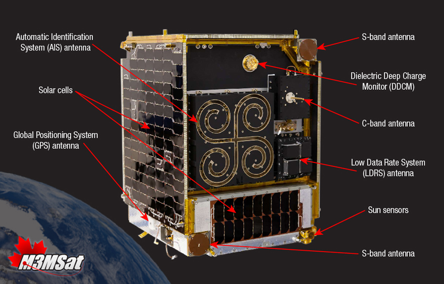
Text version
Components of M3MSat
The image identifies the main components of the M3MSat spacecraft. The satellite's box-shape frame used a new type of generic satellite platform design and was about the same size as most household dishwashers. The following components were part of the satellite, listed clockwise from the top right: S-band antenna; DDCM; C-band antenna; LDRS antenna; Sun sensors; S-band antenna; Global Positioning System (GPS) antenna; Solar cells; AIS antenna.
Credit: Honeywell (Formerly COM DEV)
Did you know?
- From bus-sized to briefcase-sized to shoebox-sized…
-
Technological advancement seems to be synonymous with miniaturization. Just think about the first computers and mobile telephones compared to what we have today. Space technology is no exception. In a field where smaller, lighter materials are more economical to make and launch, microsatellites are on the rise. The term microsatellite usually refers to satellites that are between 10 and 100 kilograms.
How it was operated
During its mission, M3MSat circled Earth from pole to pole at an altitude of 505 km. It travelled over Canadian waters approximately 10 times a day. Before its ownership transfer in , the satellite was owned by DRDC and operated by the CSA. Operators could use AIS aboard M3MSat independently or in conjunction with RADARSAT-2 by comparing Synthetic Aperture Radar images with information captured by M3MSat.
Images of M3MSat
Image 1

Credit: Defence Research and Development Canada (DRDC)
Image 2

Credit: Defence Research and Development Canada (DRDC)
Image 3

Credit: Defence Research and Development Canada (DRDC)