The Earth Observation Service Continuity initiative: beyond the RADARSAT Constellation Mission
The Government of Canada relies on Earth observation (EO) data to deliver many services to Canadians, including shore erosion and ice monitoring, flood warning and ship detection. Canada has unique EO needs due to its vast territory and remote locations.
The RADARSAT Constellation Mission (RCM) is Canada's latest generation of EO satellites. The three identical satellites work together to provide daily images of Canada's land and maritime approaches, as well as images of the Arctic. This imagery is essential for many applications, such as monitoring the environment and the North, supporting emergency response teams and making marine travel safer.
The Earth Observation Service Continuity (EOSC) initiative is looking at ways to ensure continuous access to satellite radar EO imagery beyond the lifetime of the RCM.
The RADARSAT legacy
For more than 25 years, images from RADARSAT-1, RADARSAT-2 and the RCM have been of enormous value to the Government of Canada. The RADARSAT satellites are equipped with synthetic aperture radar (SAR), a powerful microwave instrument that transmits and receives signals to capture high-quality images of Earth. A unique benefit of this technology is its ability to image night and day, and in all weather conditions.
New innovative solutions for EO

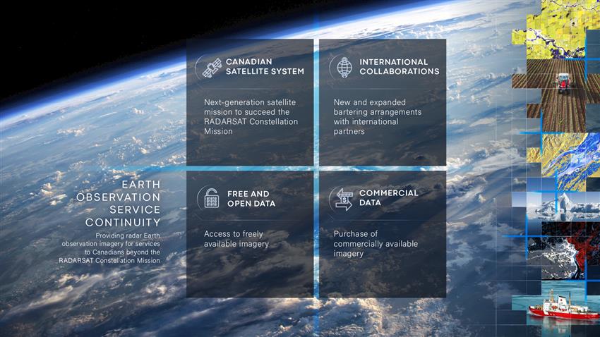
Infographic presenting the four sources of data being considered under the Earth Observation Service Continuity initiative. (Credits: Canadian Space Agency, satellite images: Dromadaire Géo-Innovations/KorrAI Technologies using RADARSAT Constellation Mission imagery © Government of Canada (). RADARSAT is an official mark of the Canadian Space Agency)
Since the launch of the RCM in , technology has progressed and EO needs have evolved. This is why through the EOSC initiative, we are reassessing these needs and exploring the emerging technologies that can help meet them. After three successful generations of RADARSAT, the next generation of satellite assets and supporting infrastructure could look different.
The Government of Canada is exploring all available options to provide ongoing data access so that there is no break in the provision of essential services to Canadians. We are exploring:
- access to free and open data
- purchase of commercial data
- collaboration with international partners
- construction and use of government-owned sensors and satellites
Consultations with other federal government departments
As part of its mandate, the Canadian Space Agency (CSA) helps other federal government departments meet their satellite EO needs. The CSA consults with key users to understand and identify their future needs in order to guide the definition and implementation of cost-effective solutions. Natural Resources Canada, Environment and Climate Change Canada, Fisheries and Oceans Canada, Agriculture and Agri-Food Canada and the Department of National Defence, among others, are actively collaborating in this process.
Development of innovative solutions and concepts
Since , eight companies have received funding to develop and propose concept solutions for the EOSC. After all eight companies submitted their initial analysis, the CSA provided additional funding to four of them – MDA, Airbus, C-Core and Alpha Insight – to further develop their concepts.
The Government of Canada continues to explore the most promising technological ideas. In fall 2022, the CSA issued a Request for Proposals, inviting industry to propose technology R&D projects in support of future radar EO projects, like the EOSC. This request focuses on assessing the feasibility and risks of key enabling technologies that might be required for future projects. Ten contracts were awarded under the CSA's Space Technology and Development Program (STDP) to five companies: AstroCom, Calian, C-CORE, EarthDaily Analytics and MDA.
Open data
In line with the spirit of open government and global trends, the CSA is aiming to make its EO data available to the broadest extent possible. The goal is to help:
- advance science and knowledge in a variety of domains, including climate change
- foster innovation and fuel Canada's digital economy
- broaden and strengthen the Canadian and international EO communities
Public and government users can access satellite images and data products through the Earth Observation Data Management System (EODMS), managed by Natural Resources Canada. The public also has access to the CSA's Open data and information Portal.
