
Winterscape
Credit: Wood Canada Limited. Contains modified Copernicus Sentinel-2 data processed by ESA
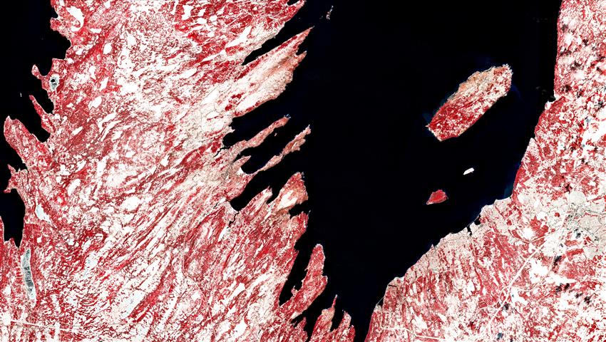
- Location: The southern part of Conception Bay, Newfoundland and Labrador
- Company: Wood Canada Limited
The European Sentinel-2 satellite took this image of eastern Trinity Bay and the southern part of Conception Bay, Newfoundland and Labrador, on a beloved provincial holiday – Saint Patrick's Day – . The image covers an area of 60 km by 40 km at 10 m resolution. The false-colour infrared band combination commonly highlights vegetation cover.
Our company often utilizes such data for projects involving habitat classification, vegetation health, and vegetation proximity analysis, such as in powerline corridors. Vegetation strongly reflects near-infrared wavelengths; in this case it is softwood evergreen tree cover that is represented in red. The dominant red-and-white combination lends the scene a very Canadian flavour. Imagery like this can also be used to map and monitor ice breakup in lakes and rivers, which can be seen in several lakes across the area.
Candace MacDonald is a GIS and remote sensing specialist with Wood Environment & Infrastructure Solutions, a division of Wood Canada Limited. She has been in the geomatics industry for over 12 years and has contributed to numerous publications, primarily involving habitat classification or flood risk mapping. While lidar data is her specialty, she is also an expert at exploiting information from air photos and satellite imagery. She served as president of the Geomatics Association of Nova Scotia for several years, and calls Wolfville, Nova Scotia, her home.