
Canada's Strategy for Satellite Earth Observation
Delivering the vision: Our objectives
2 Harness satellite EO to address climate change and issues that matter to Canadians
Increasingly, satellite EO is helping businesses, communities, and governments become more Resilient in the face of climate change. However, keeping pace with change is not enough; Canada needs be ahead of the curve when it comes to generational and global challenges. In pursuit of this, Canada will:
- Generate solutions for climate change mitigation and adaptation
International efforts have recognized that over half of the essential observations needed to understand our changing climate can only be collected by satellites. In alignment with the Pan-Canadian Framework on Clean Growth and Climate Change, Canada is committed to acquiring new satellite data to help mitigate and adapt to climate change. Around the world, countries are investing to support their scientists and to position their economies and populations to thrive in a new climate. Building on the history of GC innovation in Earth observation techniques and science, we will advance new missions to study issues that matter most to Canadians, such as the Arctic, air quality, water management, and forest fires. Additionally, the GC will explore new data sets by launching pilot programs for commercial data purchases and testing of pre-commercial offerings that can provide new insights into how our planet is changing. - Measure key environmental and health indicators
From identifying threats to biodiversity to developing early warning systems for disease outbreak, protecting Canada's environment and ensuring the health of Canadians requires increasingly dynamic information. Today, a fundamental aspect of environmental management and public health monitoring is the need to detect changes rapidly and identify their causes and consequences. Recent work by GC scientists in machine learning and big data analytics has opened up opportunities for detailed and rapid change detection in both natural and built environments, such as reduced air quality in cities, the health of Canada's wetlands, and the movement of invasive species. Satellite EO is also being used to make regulatory compliance and standards certification easier, more cost-effective, and safer through rapid satellite observations. Recognizing the importance of environmental and public health issues, such as pandemic response, the GC will advance its monitoring and forecasting abilities through investments in big data analytics tools and high-resolution, rapid-revisit satellite imagery.
Satellite EO in action:
Mapping Canada's Environment with Machine Learning
It takes 36,000 satellite images to capture all of Canada's 9.985 million square kilometres. Then, it takes an advanced machine learning algorithm to identify and sort the data into the 19 land cover classes our nation has from coast to coast to coast. For this task, high-performance computing is needed to process the 665 billion pixels, and over 100 terabytes of data, to create Canada's National Land Cover map. As the algorithm processes more land cover samples over time, it learns to categorize each pixel even more accurately. Advancements in machine learning, such as this, put otherwise unattainable views of ecosystems, biodiversity and land use change details into the hands of decision makers addressing major issues such as climate change and species conservation.
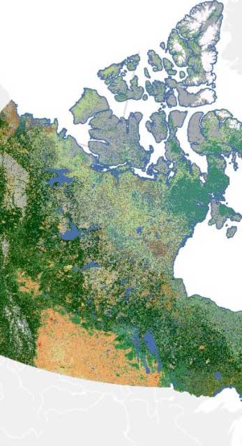
A machine learning-derived map of Canada's different types of land cover. (Credit: Transport Canada)