
Antarctic mapping mission (AMM)
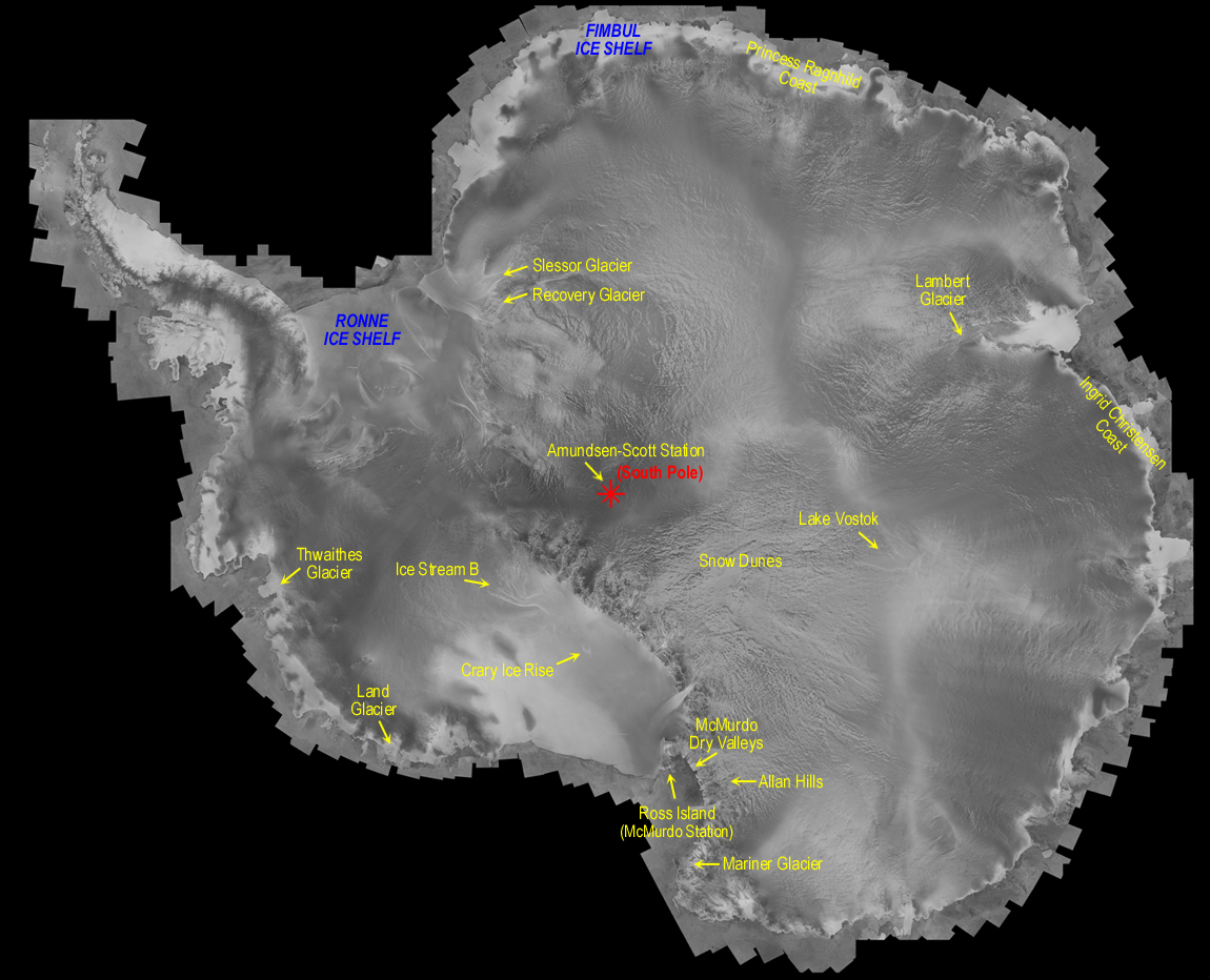
Text version - graphic about the first complete and uniform mosaic of Antarctica created from radar synthetic aperture
Fimbul ice shelf
- Princess Ragnhild Coast
- Lambert Glacier
- Ingrid Christensen Coast
- Mariner Glacier
- Ross Island (McMurdo Station)
- Allan Hills
- McMurdo Dry Valleys
- Crary Ice Rise
- Land Glacier
- Thwaithes Glacier
- Ice Stream B
Ronne ice shelf
- Slessor Glacier
- Recovery Glacier
Amundsen-Scott Station (South Pole)
- Lake Vostok
- Snow Dunes
RADARSAT Data © Canadian Space Agency (CSA) . Received and processed by the Alaska SAR Facility. Mosaic prepared by the Byrd Polar Research Center of Ohio State University. Project sponsored by National Aeronautics and Space Administration (NASA).
The above figure is a low-resolution version of the first seamless mosaic of Antarctica, which was compiled from synthetic aperture radar images.They were acquired by the Canadian Satellite RADARSAT-1 between September and as part of the Antarctic mapping mission (AMM) a collaboration between the U.S. the NASA and the CSA to completely map the Antarctic with RADARSAT-1.
The mosaic was created at the Byrd Polar Research Center using a mapping system developed by Vexcel Corporation. The Alaska SAR Facility (ASF) processed all of the raw signal data into images. The Jet Propulsion Laboratory (JPL) developed the mission acquisition plan. In addition, the project received assistance from the National Science Foundation (NSF) and the National Imagery and Mapping Agency (NIMA).
What is AMM?
Antarctica, a region the size of Canada and Alaska combined, has never been fully mapped from space at high resolutions. The AMM was aimed at completing this mapping. Such coverage was not possible with existing or previous space-borne high-resolution sensors because of their orbit inclination and/or field-of-view capability.
Participants
Partners in the AMM included the CSA and NASA. The CSA supported draws upon the Canada Centre for Remote Sensing (CCRS) and MacDonald, Dettwiler and Associates Limited (MDA) Geospatial Services. NASA supported draws upon its own facilities: ASF, JPL, and the Goddard Space Flight Center (GSFC), as well as the Byrd Polar Research Center of Ohio State University (OSU), Vexcel Corporation, the Environmental Research Institute of Michigan (ERIM), NSF and the NIMA.
Science benefits and opportunities
The RADARSAT-1 AMM had an important significance for the scientific community. Almost 70% of the Earth's fresh water is contained in the Antarctic region, and changes in this enormous reservoir directly influence world sea-levels and climate.