
NASA Space Apps Challenge
From -, participants in three Canadian cities are joining developers, designers, students, engineers and entrepreneurs from around the world to create original applications during NASA's annual Space Apps Challenge.
Space Apps is an international hackathon that occurs over 48 hours in cities around the world. Participants work alone or with a team to share ideas and engage with open data to address real-world problems, on Earth and in space.
Canadian participation

Canadian Space Agency (CSA) Astronaut Jeremy Hansen will connect with participants at local events in Toronto ( evening) and Waterloo ( morning).
CSA challenges
This year, as part of Canada's open government commitments, the CSA is making some datasets available, just in time for Space Apps! We are also presenting challenges to Canadian locations.
Have you been dreaming about time travel? CSA's challenges invite you to travel back in time or peer into the future to create solutions for real-world problems here on Earth!
CSA awards! The best solution or tool developed in response to each of the CSA challenges will be selected from the finalists nominated in each Canadian location (Ottawa, Toronto and Waterloo). These creations will be featured on the CSA website and winning team members will receive the following prize: CSA swag and a VIP invitation to visit the John H. Chapman Space Centre, CSA headquarters.
Explore the challenges and datasets.
Credit: CSA
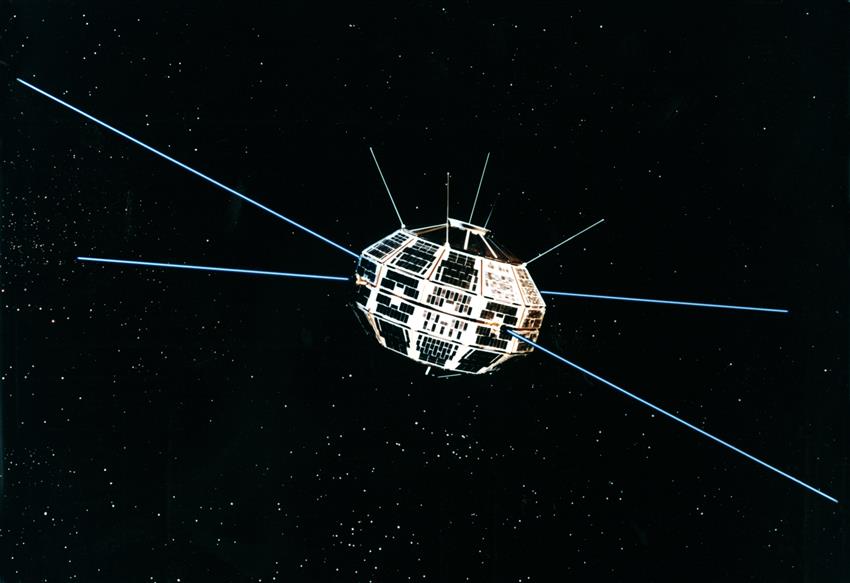
Challenge 1: Be part of Canada's legacy in space!
Images from Canada's very first satellite, Alouette-I, have been digitized! This data has rich historical value and is of interest to scientists today. The images can help us study how activity in the ionosphere can interfere with satellite signals for navigation, positioning and communications.
Your challenge? Go back in time and create a tool that will decipher the numeric and the Binary Digital Coding (BDC) used in . Your tool will help manage the thousands of ionosphere images recently scanned by the CSA.

Credit: RADARSAT Constellation Mission (RCM) Simulated Data Derived from RADARSAT-2 Data and Products © MacDonald, Dettwiler and Associates Ltd. () – All Rights Reserved. RADARSAT is an official mark of the Canadian Space Agency
Challenge 2: Get ready for next generation Earth observation data!
In preparation for the launch of the RCM, the CSA is releasing simulated RCM data. You could be among the first to access the simulated data products and see how the RCM data format is different from previous RADARSAT missions. Because the data format is different, the freeware available for RADARSAT-2 cannot read it.
Your challenge? Design the first program to read RCM data products.
Credit: RADARSAT-2 Data and Products © MacDonald, Dettwiler and Associates Ltd., . In collaboration with the Canadian Ice Service. All Rights Reserved. RADARSAT is an official mark of the Canadian Space Agency
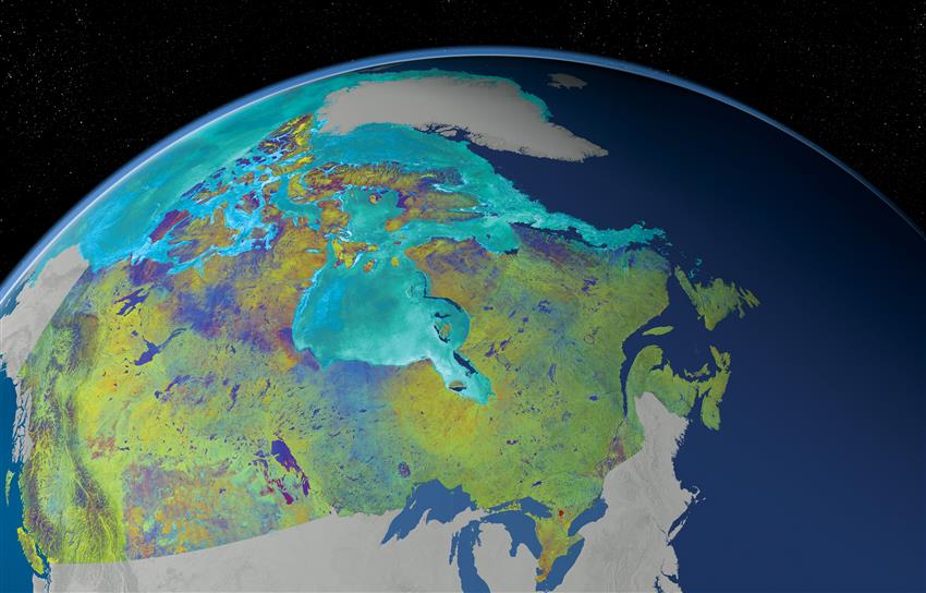
Challenge 3: Design your own challenge!
Browse through the available Canadian space datasets and be inspired!
Access the 121 RADARSAT-2 images used to create this Mosaic of Canada or use the long-term atmospheric and climate data collected by SCISAT, OSIRIS, or MOPITT (archived on external websites).
Follow your instincts to create an original application or solution of your choosing!
CSA datasets
- Advanced MOST Science Archive (Open Government)
- Alouette-I data (Open Government)
- Balloon-borne Large Aperture Submillimeter Telescope (BLAST) Data (Open Government)
- CARISMA Magnetometer Network data (Open Government)
- Far Ultraviolet Spectroscopic Explorer telescope (FUSE) satellite Data (Open Government)
- Laser-Induced Breakdown Spectroscopy (LIBS) dataset for materials for planetary exploration (Open Government)
- Measurements of pollution in the troposphere (MOPITT) data
- Optical Spectrograph and InfraRed Imaging System (OSIRIS) data
- RADARSAT-1 data over Vancouver (CSA FTP site)
- RADARSAT-2 data – Mosaic of Canada (Open Government)
- RADARSAT-2 data over Vancouver (CSA FTP site)
- Riometer historic datasets (Open Government)
- SCISAT data
- Simulated RCM data over Vancouver (CSA FTP site)
Open Government
Explore how the Government of Canada is working with the national and international open government community to create greater transparency and accountability, increase citizen engagement, and drive innovation and economic opportunities through open data, open information, and open dialogue.