
Space apps : CSA challenges and datasets
Challenge 1: Be part of Canada's legacy in space!
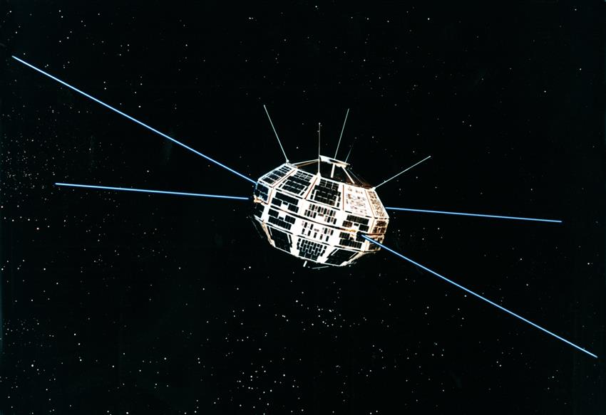
Credit: Canadian Space Agency (CSA)
Images from Canada's very first satellite, Alouette-I, have been digitized! This data has rich historical value and is of interest to scientists today. The ionograms show details in the layers of the ionosphere that can help us understand subtle variations in signals that are transmitted by highly sophisticated Global Navigation Satellite Systems (GNSS) and telecommunication satellites.
Your challenge? Go back in time and create a tool that will decipher the numeric and the Binary Digital Coding (BDC) used in . Your tool will help manage the thousands of ionosphere images recently scanned by the CSA.
Launched on , the Alouette-I scientific satellite marked Canada's entry into the space age and was seen by many as initiating the most progressive space program of that era. In its first three months of operation, Alouette-I produced some of the most exciting data on the status of the ionosphere. Almost fifty-five years later, the CSA has digitized more than 450 canisters of 35 mm film provided by the satellite with the intent to make the images open to data users and scientists.
To help you with this challenge
Alouette-I data (Open Government)
How would a tool to manage the Alouette-I images be helpful?
The 450 digitalized film rolls offer thousands of images. Without a tool to manage them, it is difficult to efficiently use the data because it is nearly impossible to carry out effective searches. To complete this challenge, the recently digitalized ionograms will be provided to participants with a supporting document presenting the images and explaining the metadata.
What type of application or tool would be appropriate?
The challenge is not to interpret the ionogram images but to read and interpret the metadata found in each one. Once this information is electronically recognized, it could be integrated in a database. A tool could then use this database to manage the information by allowing searches according to specific criteria such as the receiving station facility, date, etc.
About Alouette-I
Alouette-I is best known for its swept-frequency topside sounder experiment. The satellite did not have a tape recorder or any other way to store data on-board and the only way to obtain data was to record it when the satellite was in the range of a receiving station.
The Alouette-I mission resulted in over 300 publications in refereed scientific journals. About 80 percent of the Alouette-I publications were based on the ionograms obtained from the topside sounder experiment.
In its first 3 years of operation, Alouette-I obtained over a million ionograms, each equivalent to a snapshot of the ionosphere from 1000 km down to about 300 km in altitude. These ionograms have provided data at all geomagnetic latitudes and at geographic latitudes ranging from 80° N to 80° S. After 10 years, Alouette-I had produced two million ionograms.
The satellite carried four scientific experiments:
- Sweep-Frequency Sounder. This experiment measured the electron density distribution in the ionosphere by measuring the time delay between the emission and return of radio pulses. The sounder was able to emit pulses with frequencies between 1 and 12 megahertz, with a power of 100 W.
- Energetic particle detectors. An arrangement of Geiger counters and scintillators for detecting energetic particles.
- VLF Receiver. An experiment for measuring both artificial and natural VLF signals. It was sensitive to frequencies between 400 and 10,000 hertz.
- Cosmic Radio Noise. Two long radio antennas for detecting radio noise from the Sun and the Galaxy.
Challenge 2: Get ready for next generation Earth observation data!

Credit: RADARSAT Constellation Mission (RCM) Simulated Data Derived from RADARSAT-2 Data and Products © MacDonald, Dettwiler and Associates Ltd. () – All Rights Reserved. RADARSAT is an official mark of the Canadian Space Agency
In preparation for the launch of Canada's next RADARSAT system, the RCM, the CSA is releasing simulated RCM data – just in time for the Space App Challenge! You could be among the first to access the simulated data products and see how the RCM data format is different from previous RADARSAT missions… and attack a real challenge for future data users.
Your challenge? Create a software to help users read RCM data products when they become available.
Your work could help government, industry and academic users to better understand the impact of each RCM beam mode specification (e.g. system noise, spatial resolution, and spatial coverage). This would help minimize the impact of the new data format for RADARSAT data users and maximize the use of the future RCM data which will support critical activities like maritime surveillance, disaster management and ecosystem monitoring.
To help you with this challenge
RCM simulated data over Vancouver is available, along with archived RADARSAT-1 and RADARSAT-2 products of the same area.
- Simulated RCM data over Vancouver (FTP site)
- RADARSAT-2 data over Vancouver (FTP site)
- RADARSAT-1 data over Vancouver (FTP site)
Two freewares that display and analyze RADARSAT-1 and RADARSAT-2:
About RCM
A top priority of the CSA today is the development and delivery of the RADARSAT Constellation. Planned for launch in , the RCM is made up of three identical satellites. It is designed to build on Canada's Earth observation capabilities, particularly for maritime surveillance (ice, surface winds, oil pollution and ship monitoring), disaster management (mitigation, warning, response and recovery) and ecosystem monitoring (agriculture, wetlands, forestry and coastal change monitoring).
The constellation approach distributes capabilities across several small satellites to deliver fast and cost-effective information and services. RCM will offer daily coverage of Canadian maritime approaches and the possibility of imaging any point over 90% of the world's surface every 24 hours. It will also significantly increase our coverage of the Canadian Arctic with up to four passes per day in Canada's far north, and several passes per day over the Northwest Passage.
Challenge 3: Design your own challenge!
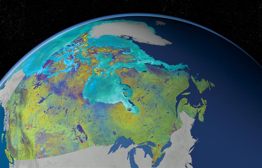
Credit: RADARSAT-2 Data and Products © MacDonald, Dettwiler and Associates Ltd., . In collaboration with the Canadian Ice Service. All Rights Reserved. RADARSAT is an official mark of the Canadian Space Agency
Browse through the available Canadian space datasets and be inspired!
Access the 121 RADARSAT-2 images used to create this Mosaic of Canada or use the long-term atmospheric and climate data collected by SCISAT, OSIRIS, or MOPITT (archived on external websites).
Follow your instincts to create an original application or solution of your choosing!
To help you with this challenge
- Advanced MOST Science Archive (Open Government)
- Alouette-I data (Open Government)
- Balloon-borne Large Aperture Submillimeter Telescope (BLAST) Data (Open Government)
- CARISMA Magnetometer Network data (Open Government)
- Far Ultraviolet Spectroscopic Explorer telescope (FUSE) satellite Data (Open Government)
- Laser-Induced Breakdown Spectroscopy (LIBS) dataset for materials for planetary exploration (Open Government)
- Measurements of pollution in the troposphere (MOPITT) data
- Optical Spectrograph and InfraRed Imaging System (OSIRIS) data
- RADARSAT-1 data over Vancouver (CSA FTP site)
- RADARSAT-2 data – Mosaic of Canada (Open Government)
- RADARSAT-2 data over Vancouver (CSA FTP site)
- Riometer historic datasets (Open Government)
- SCISAT data
- Simulated RCM data over Vancouver (CSA FTP site)