
RADARSAT-2 images archives in South America
Extent of flood devastation in Brazil
Location
Image acquired on January 8, 2012 by Canadian satellite RADARSAT-2
On January 7, 2012, the dam at Campos dos Goytacezes, Brazil burst causing extensive flooding in the Minas Gerais, Espirito Santos, and Rio de Janeiro regions. At the same time a number of mudslides struck the city of Belo-Horizonte, killing 6 people. The Brazilian authorities have evacuated more than 20,000 people and a state of emergency was declared in the region. Civil defense officials were deployed to handle the worst affected areas in an attempt to prevent further loss of life.
The Ministry of Defense and the Instituto Nacional de Pesquisas Espacials (INPE)(Brazil) requested the acquisitions of Earth Observation (EO) imagery over Brazil in order to better manage the disaster crisis. In response, the Canadian Space Agency (CSA) acquired multiple RADARSAT-2 images over affected areas during the week following the flood event. The CSA Earth Observation Applications and Utilizations (EOAU), in close collaboration with Hatfield Consultants Partnership (North Vancouver, Canada), have developed change detection maps with RADARSAT-2 and RADARSAT-1 images in less than 48 hr. The products were developed through the CSA Rapid Information Products and Services (RIPS) initiative.
The following images highlight areas of flood throughout Campos dos Goytacezes and show the extent of devastation. The image on the left depicts the area prior to flooding and the image on the right depicts post flood conditions with newly flooded areas highlighted in red.
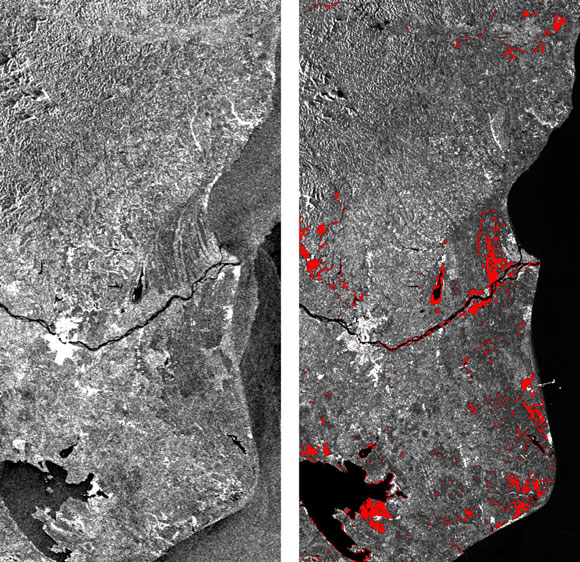
Credit: Copyrights: RADARSAT-2 Data and Products © MacDonald, Dettwiler and Associates Ltd. (MDA). (2012) – All rights reserved. RADARSAT is an official mark of the CSA. This product was developed by the CSA Earth Observation Applications and Utilizations (EOAU) under it’s Rapid Information Products and Services (RIPS) initiative.
Haiti - Les Gonaives: Before and after the passage of hurricane Tomas
Location
Situation report
Hurricane Tomas hit the west part of Haiti on November 5th, causing floods in many areas, including Gonaives. Certain regions were only accessible by helicopter since many roads were cut off owing to flooding and land and mudslides.
Note on RADARSAT-2 imagery
A set of two images acquired by the Canadian RADARSAT-2 satellite on November 5 (before 'Tomas') and on November 6 (after 'Tomas') were processed to extract information on changes that occured following the hurricane's passage. Generally, the radar signal is sensitive to terrain features, fine-scale surface roughness, and dielectric properties and orientation of materials, e.g. moisture content, buildings. It also provides a clear delineation between land and water surfaces, thus helping to map flooded areas.
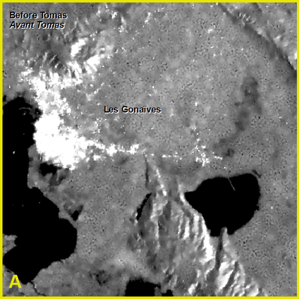
November 5, 2010 - Before Tomas (Credit: RADARSAT-2 Data and Products © MDA (2010) – All rights reserved. RADARSAT is an official mark of the CSA.)
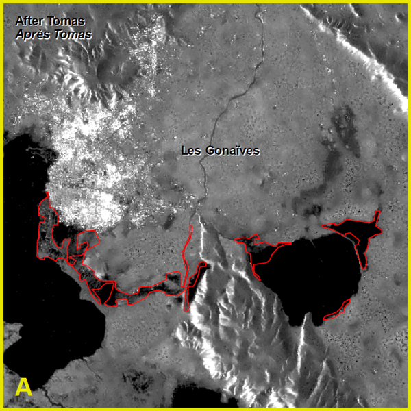
November 6, 2010 - After Tomas (Credit: RADARSAT-2 Data and Products © MDA (2010) – All rights reserved. RADARSAT is an official mark of the CSA.)
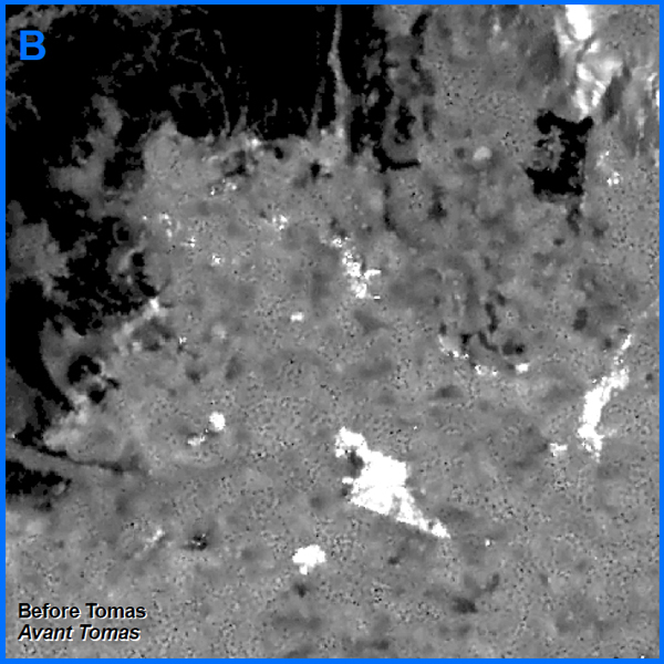
November 5, 2010 - Before Tomas (Credit: RADARSAT-2 Data and Products © MDA (2010) – All rights reserved. RADARSAT is an official mark of the CSA.)
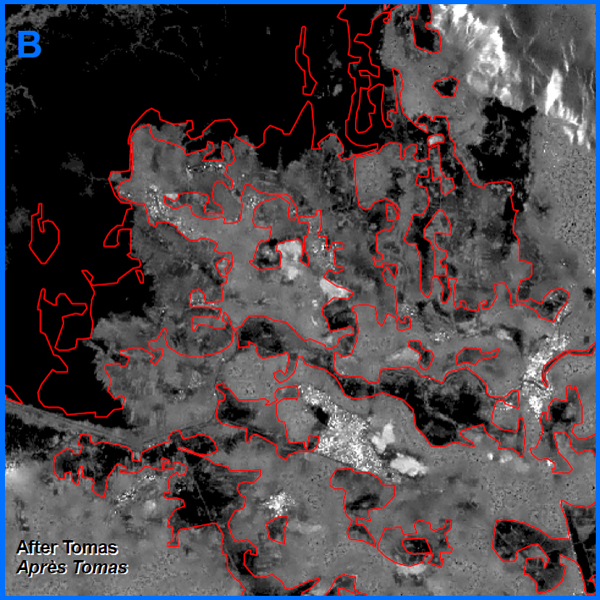
November 6, 2010 - After Tomas (Credit: RADARSAT-2 Data and Products © MDA (2010) – All rights reserved. RADARSAT is an official mark of the CSA.)
Earthquake in the Republic of Haiti - City of Port-au-Prince
Location
The background visual is a RADARSAT-2 image. Red squares are identifying different locations in the downtown area of Port-au-Prince, which are:
- A: Presidential Palace
- B: Port-au-Prince Cathedral
- C: The Iron Market
- D: Public Market
- E: Canada-Haiti College
- F: Port-au-Prince Airport
- Region:
- Port-au-Prince, Haïti
- Sensor:
- RADARSAT-2
- Acquisition date:
- January 14, 2010 at 5:47 EST
- Mode and beam:
- Ultra-Fine, beam 77
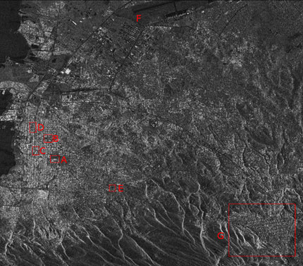
To see more images of the Earthquake in Haiti, visit the International Charter Space and Major Disasters web site. (Credit: RADARSAT-2 Data and Products © MDA (2010) – All rights reserved. RADARSAT is an official mark of the CSA.)
An oil platform spilling oil in the Gulf of Mexico
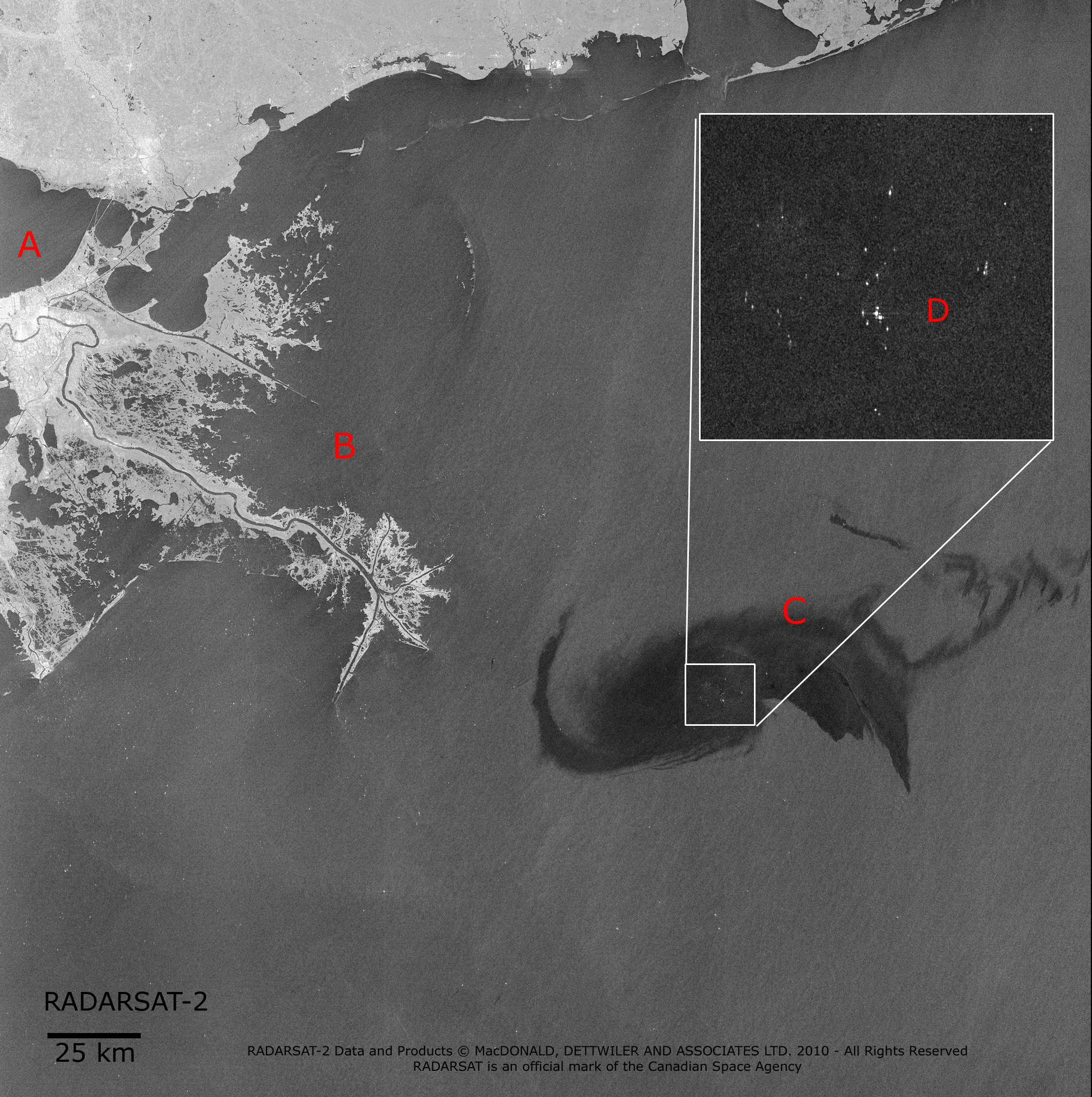
An oil platform located 70 km from the coast of Louisiana sank on Thursday April 22, 2010 in the Gulf of Mexico spilling oil into the sea. On these two RADARSAT images we can clearly see the evolution of the spill, which has a darker tone than the surrounding water, as well as some boats in the area.
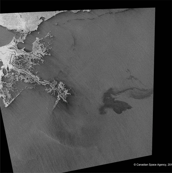
Credit: RADARSAT-2 Data and Products © MDA (2008) – All rights reserved. RADARSAT is an official mark of the CSA.
Following first image was acquired by RADARSAT-1 in ScanSAR Narrow A Beam on April 26, 2010 at 11:59:39 UTC, while the second image was acquired by RADARSAT-2 in ScanSAR Narrow B Beam on April 28, 2010 at 11:51:29 UTC.
- A: New Orleans, Louisiana
- B: Delta of the Mississippi River
- C: Oil slick
- D: Close-up of ships and equipments
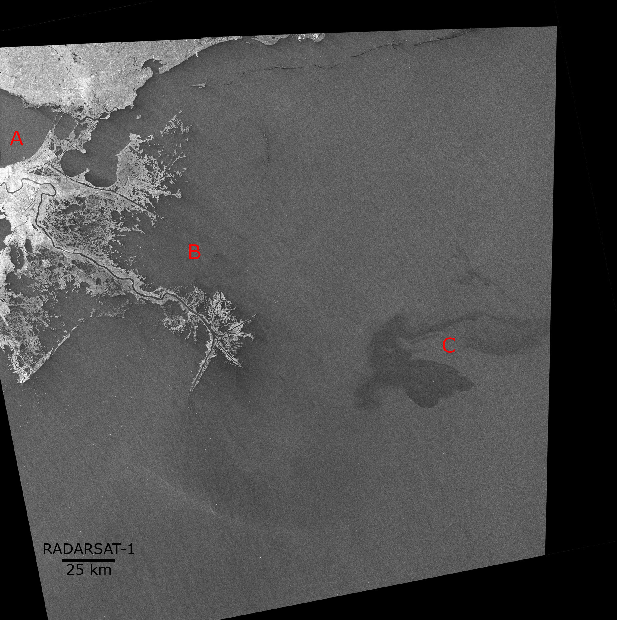
Credit: RADARSAT-2 Data and Products © MDA (2008) – All rights reserved. RADARSAT is an official mark of the CSA.
Credit: RADARSAT-2 Data and Products © MDA (2008) – All rights reserved. RADARSAT is an official mark of the CSA.
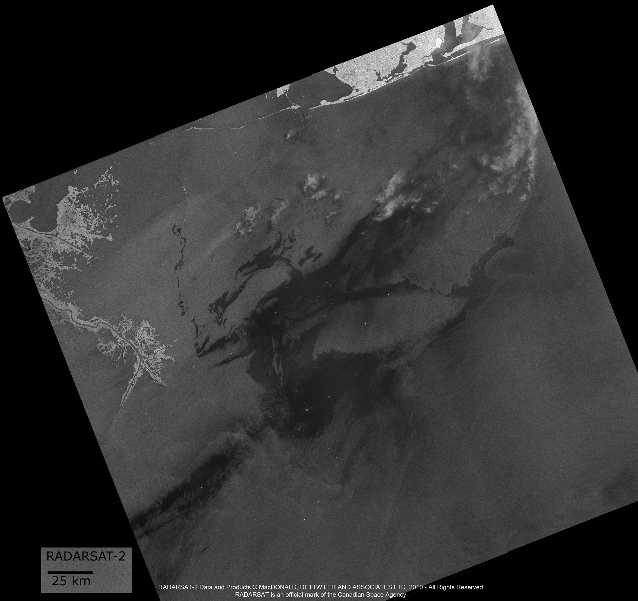
Image acquired on May 3, 2010. (Credit: RADARSAT-2 Data and Products © MDA (2008) – All rights reserved. RADARSAT is an official mark of the CSA.)
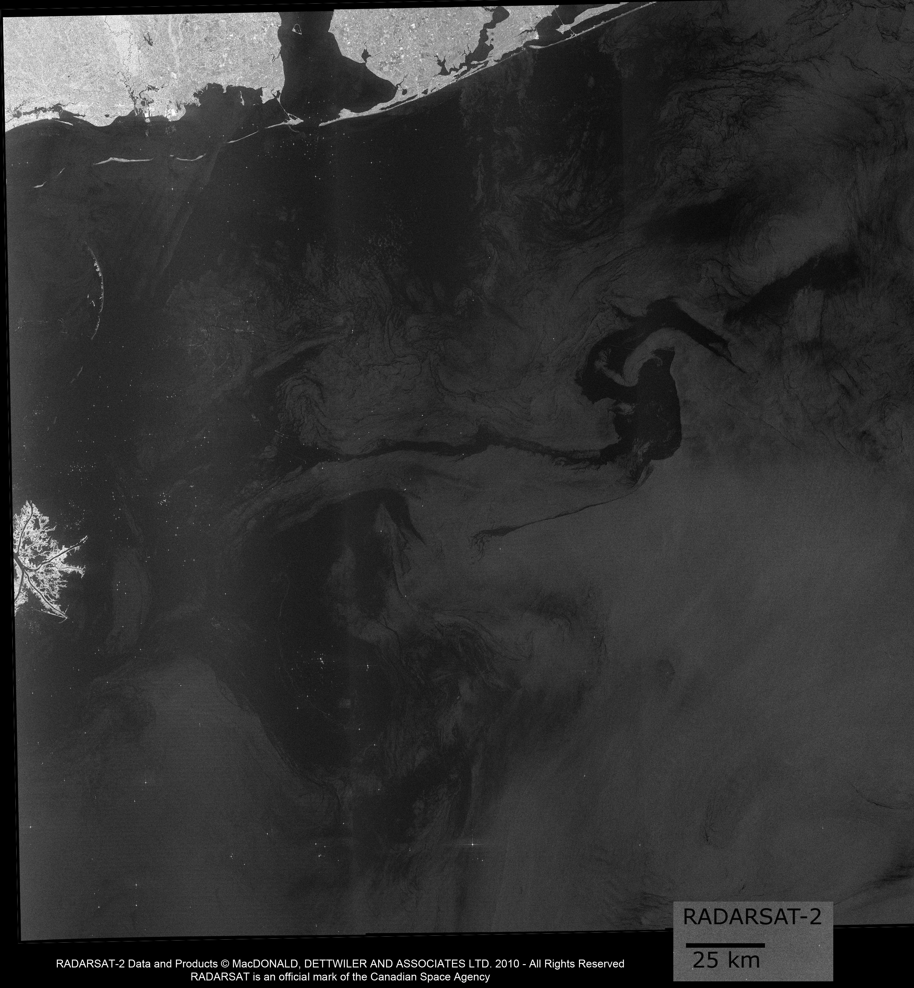
Image acquired on May 5, 2010. (Credit: RADARSAT-2 Data and Products © MDA (2008) – All rights reserved. RADARSAT is an official mark of the CSA.)
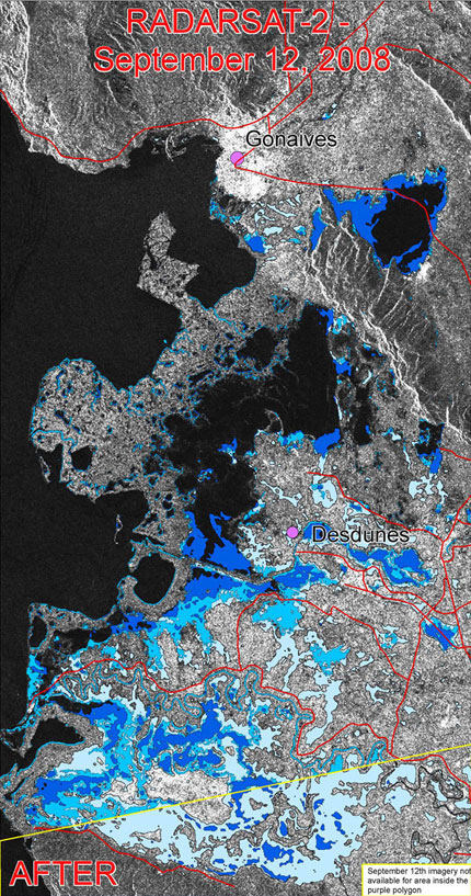
Flooding in Haiti
In less than a month and since August, 2008, four major tropical storms/hurricanes hit Haiti: Fay, Gustav, Hanna and Ike. The UN stated that Hurricane Ike hit Haiti hardest in the Caribbean and estimated around September 15, 2008 that some 800,000 Haitians, of which 300,000 children, were made homeless. Hundreds were reported dead following the weeks of successive tropical storms and hurricanes. The UN World Food Program said that the deadly storms displaced hundreds of thousands of people and destroyed several homes and plantations. A September 15, 2008 UN news bulletin claimed that about 60% of the Haitian town of Gonaives was under water.
Advanced capabilities of the proven Canadian RADARSAT-1 satellite and its next generation RADARSAT-2 were called upon in this crisis situation. The CSA produced images from its RADARSAT-1 data, while RADARSAT-2 data and image processing was gratefully provided by MDA/GSI in this emergency context to support the International Charter "Space and Major Disasters" operations. The Canadian Centre for Remote Sensing used this satellite data to map the limits of the flood extent. Hence, in collaboration with its international partners, Canada is supporting other Nations and their front-line responders by contributing substantial improvements in imaging natural disasters, which is helping improve the management and evaluation of the impact of these disasters on human life and property.
For more information, please see the Charter site: Hurricanes in Haiti.
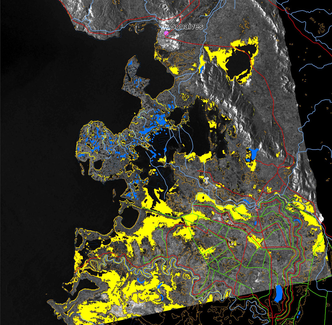
Location
The background visual is a RADARSAT-2 image. Highlighted areas of the flood recession in the Gonaives and Desdunes regions of Haiti can be visualised by comparing the light blue vectors derived from a Japan Aerospace Exploration Agency (JAXA)-managed ALOS Satellite for September 9th, compared to the medium blue vectors obtained from CSA's RADARSAT-1 data on September 10th, compared to the dark blue vectors of data gained from Canada's RADARSAT-2 on September 12th. The open water flood vectors were created by the emergency response team at the CCRS (CCRS) of Natural Ressources Canada.
Flooding in Haiti – multi-dated image
- Region:
- Gonaïves et Desdunes, Haïti
- Sensor:
- ALOS
- Acquisition date:
- February 9, 2008
- Incident angle:
- 34,3 degrees
- Space between pixels:
- 6,25 m
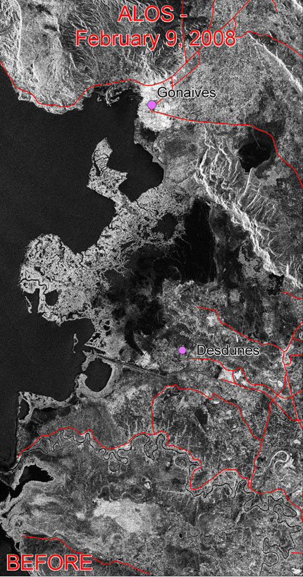
ALOS imagery © JAXA, 2008. Interpretation and mapping by the Canadian Centre for Remote Sensing, NRCan. (Credit: RADARSAT-2 Data and Products © MDA (2008) – All rights reserved. RADARSAT is an official mark of the CSA.)
Flooding in Haiti – multi-dated image
- Region:
- Gonaives et Desdunes, Haïti
- Sensor:
- RADARSAT-2
- Acquisition date:
- September 12, 2008
- Mode and beam:
- Standard 3 (S3), HH
RADARSAT-2 Data and Products © MDA. (2008) – All rights reserved. Interpretation and mapping by the Canadian Centre for Remote Sensing, NRCan.
- Region:
- Gonaïves et Desdunes, Haïti
- Sensor:
- RADARSAT-1
- Acquisition date:
- 10 septembre 2008
- Mode and beam:
- Fine 3 far (F3f), HH
© CSA, 2008. Interpretation and mapping by the Canadian Centre for Remote Sensing, NRCan.
Credit: RADARSAT-2 Data and Products © MDA (2008) – All rights reserved. RADARSAT is an official mark of the CSA.
Flooding in Haiti
Location
The background visual is a RADARSAT-1 image. Highlighted areas of the flood in the Gonaives and Desdunes regions of Haiti include orange vectors derived from the JAXA-managed ALOS Satellite on September 9th and the yellow vectors were obtained from the CSA's RADARSAT-1 on September 10th. The open water flood vectors were created by the emergency response team at the CCRS of NRCan.
- Region:
- Gonaïves et Desdunes, Haïti
- Sensor:
- RADARSAT-1
- Acquisition date:
- September 10, 2008
- Mode and beam:
- Fine 3 far (F3f), HH
© CSA, 2008. Interpretation and mapping by the Canadian Centre for Remote Sensing, NRCan.
Credit: RADARSAT-2 Data and Products © MDA (2008) – All rights reserved. RADARSAT is an official mark of the CSA.