
Components and specifications

RADARSAT covered the Arctic daily, and most of Canada every 72 hours depending on where the instruments were pointing, and what they were monitoring. It covered the entire Earth every 24 days. (Credit: Canadian Space Agency)
Text version - Components and specifications of the RADARSAT-1
Components and specifications of the RADARSAT-1
- Solar Array
- Solar Array Tie-Downs
- Battery Radiator
- Zenith S-Band
- Bus Module
- Solar Array
- Payload Module
- Nadir S-Band Antenna
- X-Band Antenna
- SAR Antenna Tie-Downs
- SAR Antenna
- Extendible Support Structure
Synthetic Aperture Radar (SAR) on RADARSAT-1
RADARSAT-1 was equipped with an advanced radar sensor, the synthetic aperture radar SAR. It was a powerful microwave instrument. It transmitted and received signals for capturing high quality images of the Earth night and day and in all weather conditions. As an active sensor, RADARSAT-1's SAR transmitted a microwave energy pulse (C-band at 5.3 GHz frequency) to the Earth, and the SAR measured the amount of energy that is reflected back to the satellite from the Earth's surface.
| Launch mass (total) | 2,750 kg |
|---|---|
| Array power | 2.5 kW |
| Batteries | 3 x 48 Ah NiCd |
| Design lifetime | 5 years |
| Frequency/wavelength | 5.3 GHz/band C, 5.6 cm |
|---|---|
| Radio frequency bandwidth | 11.6, 17.3 or 30 Mhz |
| Transmitter power (peak) | 5 kW |
| Transmitter power (average) | 300 W |
| Maximum data rate | 85 Mb/s (recorded) - 105 Mb/s (R/T) |
| Antenna size | 15 m x 1.5 m |
| Antenna polarization | HH |
Credit: Canadian Space Agency
Text version - imaging modes and beam calibration information
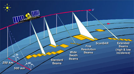
Imaging modes and beam calibration information
- Map scale : 250 km à 500 km
- Standards Beams
- Wide Swath Beams
- Fine Resolution Beams
- ScanSAR
- Extended Beams (high & low incidence)
Imaging modes and beam calibration information
RADARSAT's SAR instrument could shape and steered its radar beam using C-band. A wide variety of beam widths were available to capture swaths of 45 to 500 km, with a range of 8 to 100 m in resolution and incidence angles of 10 to 60 degrees. These images could be downlinked in real-time to the receiving stations or recorded on the on-board recorder for later downlink to Canada.
For technical information of interest to data users, please consult the pages on beam calibration.
| Mode | Nominal resolution (m) | No. of positions / beams | Swath width (km) | Incidence angles (degrees) |
|---|---|---|---|---|
| Fine | 8 | 15 | 45 | 34 - 47 |
| Standard | 30 | 7 | 100 | 20 - 49 |
| Wide | 30 | 3 | 150 | 20 - 45 |
| ScanSAR narrow | 50 | 2 | 300 | 20 - 49 |
| ScanSAR wide | 100 | 2 | 500 | 20 - 49 |
| Extended high | 18 - 27 | 3 | 75 | 52 - 58 |
| Extended low | 30 | 1 | 170 | 10 - 22 |
Credit: Canadian Space Agency
Text version - beam mode ground coverage
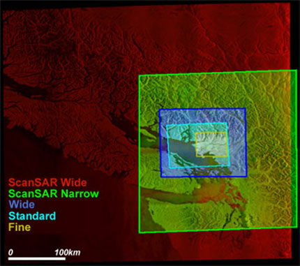
Beam mode ground coverage
- ScanSAR wide
- ScanSAR narrow
- Wide
- Standard
- Fine
- Map scale : 0 to 100 km
Beam mode ground coverage
RADARSAT could provide nearly complete global landmass coverage, and could support specific requirements. The satellite's orbit path repeated every 24 days. But RADARSAT could also:
- provide daily coverage of the Arctic,
- view any part of Canada within three days
- achieve complete coverage at equatorial latitudes every six days using the 500-km wide swath
| North of 70°N | Daily |
|---|---|
| North of 48°N | Every 4 days |
| The Earth (except the centre of Antarctica, 80°S and 90°S) | Every 6 days |
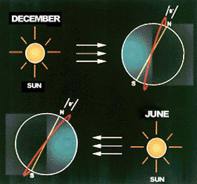
RADARSAT's dawn- to-dusk path (red line) ensured that the solar arrays were constantly exposed to the Sun, although in June-July, it was in the dark for a few minutes of each orbit over Antarctica. (Credit: Canadian Space Agency)
Text version - Synchronous orbit
Synchronous orbit
- The sun-synchronous orbit in December
- The sun-synchronous orbit in June
Orbit
RADARSAT was in orbit 798 km above the Earth, circling from pole to pole in asun-synchronous orbit. The dawn-to-duskorbit placed its solar panels in sunlight almost constantly ensuring reliable solar power and provided the optimum number of viewing opportunities.
Because of its sun-synchonous orbit, it passed over a given place at the same local time. This minimized the effects of diurnal variations and was key in obtaining data over time as is, for example, data used in predicting harvests. The satellite was rarely in eclipse and could acquire data at any time. The descending equatorial crossing for a dawn-to-dusk orbit was 6 hours.
RADARSAT could acquire up to 28 minutes of data for each 100.7-minute orbit. Data was downlinked in real time to ground receiving stations or stored on the onboard tape recorder until RADARSAT was within range of a receiving station. In critical situations, data could be processed and delivered within 4 hours of acquisition.
| Altitude | 793-821 km |
|---|---|
| Inclinaison | 98.6 degrees |
| Duration of one orbit | 100.7 min |
| Descending node | 6 hr |
| Ascending node | 18 hr |
| Sun-synchronous | 14 orbit per day |
Ground segment: Network stations
Data collected by RADARSAT-1 was transmitted directly to a Data Reception Facility or could be stored onboard for downloading later. The receiving stations provided:
- complete and reliable real-time coverage around the world
- consistency in format for high-quality products
- timely delivery of the requested data
Each new station was gradually integrated into the system in a certification process developed by the Canadian Space Agency (CSA) and MacDonald, Dettwiler and Associates Ltd. (MDA) Geospatial Services (formerly RADARSAT International). This process guaranteed a uniform, high level of performance and data quality.
Many data reception facilities were added and this has created a broad global network. By , the RADARSAT-1 network comprised 33 Data Reception Facilities, including six transportable ones for real-time coverage of nearly all the landmass on Earth.
With such a comprehensive network of receiving stations around the globe, RADARSAT-1 could deliver near-real-time, reliable monitoring services for applications such as monitoring floods, maritime pollution, and oil spills.
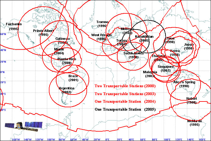
RADARSAT-1 offered global coverage through a ground station network. Additional coverage was provided by portable stations. (Credit: Canadian Space Agency)
Text version - International data reception facilities
International data reception facilities
- Argentina ()
- Brazil ()
- Puerto Rico ()
- Miami ()
- Gatineau (199X)
- Prince Albert ()
- Fairbanks ()
- Tromso ()
- West Freugh ()
- Moscou (20XX)
- Turkey ()
- Kazakhstan ()
- Saudi Arabia ()
- China ()
- Japan ()
- Korea ()
- Thailand ()
- Singapore ()
- Malaisia ()
- Alice's Spring ()
- Hobart ()
- McMurdo ()
- Two Transportable Stations ()
- Two Transportable Stations ()
- One Transportable Station ()
- One Transportable Station ()
Canadian data reception facilities
The Canada Centre for Remote Sensing (CCRS) operates two Canadian ground-receiving facilities, in Gatineau, Quebec, and Prince Albert, Saskatchewan. CCRS coordinates the acquisition services and is responsible for scheduling and reporting day-to-day operations. Imagery for public use is placed on the Web-accessible CEOCat browser and catalogue service.
International data reception facilities
The network includes two American facilities: one in Fairbanks, Alaska, and one in MacMurdo, Antarctica. Other facilities have been incorporated to ensure coverage of the Earth's landmass in the United States, the United Kingdom, Norway, Singapore, China, Australia, Korea, Japan, South Korea, and Saudi Arabia, Puerto Rico, Thailand, Brazil, Argentina, Turkey, Malaysia, Russia, and Kazakhstan.
Six portable ground stations in other parts of the world provide coverage opportunities for applications such as pollution control, oil and gas exploration, surveillance, and emergency response management.