
Space serving the Arctic and the Great Canadian North

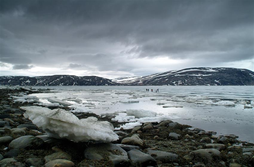
Pond Inlet, Nunavut, is located between the fjords and the Arctic Ocean. (Credit: Wikimedia)
The Canadian North and the Arctic are a vast region of ice and snow, and the home of people with rich and diverse cultures. This region is home to iconic wildlife, such as the polar bear, the walrus and the caribou. Its waters abound with marine mammals, fish, mollusks and crustaceans. Its night sky is lit up with multicoloured auroras, which can impact communications and infrastructures. Its underground is bursting with minerals such as diamonds, gold, platinum, iron and uranium. Many scientists believe that nearly a third of the world's gas and petroleum resources are hidden there.
Scientists, governments and indigenous nations use satellite data to make the best possible decisions to meet the needs of communities in the North and diversify the local economy while simultaneously preserving biodiversity.
Which satellites are used to observe the Arctic?
- RADARSAT Constellation Mission and RADARSAT-2: To facilitate marine surveillance, ice monitoring, disaster management, ecosystem monitoring, resource management and mapping in Canada and around the world.
- M3MSat: To locate ships and manage marine traffic from space.
- SMOS: To map sea surface salinity, monitor soil moisture on a global scale, better understand the water cycle, and map snow- and ice-covered areas.
- SWOT (in development): To observe ocean surfaces and measure how lakes, rivers, reservoirs and oceans are changing over time.
- THEMIS mission: To observe and measure disturbances in Earth's magnetic field.
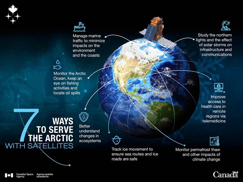
Text version - 7 ways to help the Arctic with satellites
The Arctic faces a number of challenges. Our satellites keep an eye on this vast territory and its biodiversity. (Credit: Canadian Space Agency)
Why use satellites to observe the Arctic?
Looking after the environment

The Arctic has a unique biodiversity, with a variety of wildlife, national wildlife areas and migratory bird sanctuaries. Its snowy peaks and ice floes act as air conditioners for our planet. Its numerous natural resources, including several large mineral deposits, can only be developed by preserving this ecosystem, which has already been heavily affected by climate change.
Governments use satellite data to understand changes in the environment and make the best decisions possible to protect it.
Helping monitor Canada's changing environment
As a Resource Management Officer for Parks Canada, Brian Koonoo travels extensively to the northern tundra to compile information about the changing environment. Remaining abreast of weather conditions is a key challenge to working in this potentially hazardous region where temperatures and conditions can quickly change. Koonoo uses RADARSAT data to help identify the dangerous parts of the tundra and permafrost areas and what the best routes might be. RADARSAT data is an increasingly important part of that process, as climate change has made traditional knowledge of the Arctic icescape less reliable. Read Brian's full story.
RADARSAT satellites
What are they used for?
The RADARSAT-2 and RADARSAT Constellation Mission (RCM) are very useful for monitoring oceans, including the Arctic Ocean. By closely observing ships, authorities can better detect activities on the water, keep an eye on fishing and quickly locate oil spills.
RCM satellite data on landscapes and vegetation cover in national parks will guide government decisions to foster ecosystem preservation.
SWOT
What will it do?
The SWOT mission radar will survey 90% of the Earth's surface water, particularly in the Canadian North, where little data are currently collected.
What will it be used for?
These data will provide a unique perspective on changes in lakes, rivers, reservoirs and oceans. Being better informed of the quality and quantity of water resources available, governments will be able to better evaluate the biodiversity and habitats in their areas, and better predict their evolution.
Tracking ice movement
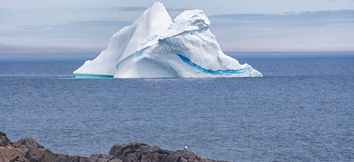
An iceberg off the Canadian coast. (Credit: Shane McKay, National Research Council of Canada)
Arctic ice is one of the ecosystems most affected by the increased temperatures caused by climate change. This phenomenon clears entire areas for navigation on the Arctic Ocean. The melting of the Northwest Passage has provided a navigation alternative, reducing the trip from Europe to Asia by 8,000 km.
Local authorities turn to space and satellites to:
- track ice changes
- better understand climate change
- ensure that sea routes and ice roads are safe
- plan new infrastructures
- support ship navigation
Navigating sea ice to deliver supplies

Credit: Michael Stokes
Michael Stokes is a ship's captain who mostly works in the Arctic. He brings food and supplies to a remote mining community. He is one of the few captains operating in the region. RADARSAT data is essential to his work. The ship he navigates is 40 years old and is the oldest in the fleet. That means he has to be extra careful to avoid getting jammed in sea ice, which risks damaging the ship. RADARSAT data provides Michael with the details that he needs to make navigation decisions to keep his crew safe and ensure the supplies are delivered. Read Michael's full story.
SWOT
What will it do?
The SWOT satellite radar will survey surface water in all its forms, including ice.
What will it be used for?
By providing precise data on ice thickness, this satellite will: increase our knowledge of ice, guide marine traffic, help decision makers plan new infrastructures in the North.
RADARSAT satellites
What do they do?
Whatever the weather conditions, the RADARSAT radars easily detect ice edges, types, topography and structure.
What are they used for?
RADARSAT-2 and RCM data enable northern communities to: accurately plan their routes, on water or ice, for hunting or fishing expeditions, monitor the impact of climate change
RCM satellites are particularly useful for: quantifying the density and strength of ice and icebergs, better understanding the formation cycle of ice and ridges, ensuring safe navigation.
Preserving our land
Inuit fishermen travelling on ice.
The Arctic Archipelago and the Canadian North represent over 40% of Canada's land territory. Because of climate change, this territory is changing quickly. The ice is melting, thereby changing the landscape, leading communities to change their habits and opening waterways for navigation.
It is essential to:
- monitor and protect the Canadian North
- look after its resources
Because they provide a comprehensive picture of the land and water, satellites offer unique solutions in this regard. They enable us to:
- ensure that activities conducted, even in isolated areas, comply with Canadian laws and respect the environment
- manage marine traffic effectively to minimize impacts on the environment and the land
- prevent or intercept any illegal activities along Canadian coasts or at sea
RADARSAT Constellation
What does it do?
Data collected by RCM satellites provides an accurate and continuous picture of ecosystems, ice, wind, pollution and ships.
What is it used for?
We are able to better monitor our land and ensure its safety, particularly in the Arctic.
M3MSat
What does it do?
Ships are equipped with an automatic identification system that transmits important information on their identity, direction and cruising speed. The M3MSat satellite is equipped with the same technology.
What is it used for?
Thanks to this satellite, we have an overview of marine traffic. Used alone or with RADARSAT-2 and RCM information, these data enable us to identify ships and observe their activities in our waters.
Providing health care in isolated regions
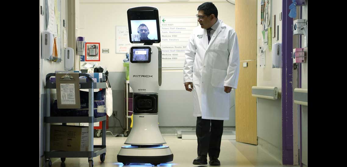
Credit: University of Saskatchewan robotic telemedicine program
In northern communities, it is not always easy to access medical care. Technological progress in satellites has led to the creation of systems and applications that are revolutionizing public health care services, particularly for people living in remote or isolated regions. In the health care field, the use of these technologies is called "telemedicine.
"
Canadian telecommunications satellite
What does it do?
Anik F2 provides access to wireless broadband Internet in the most remote regions in Canada.
What is it used for?
Broadband Internet services provide numerous advantages to medical personnel in remote or isolated regions, including: monitoring patients remotely, accessing specialist advice via videoconference, continuing professional development
Observing and studying the northern lights
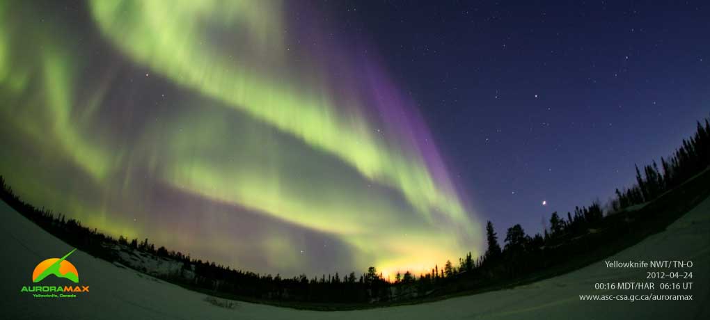
A collaboration between the University of Calgary, the City of Yellowknife, Astronomy North and the Canadian Space Agency, AuroraMAX is a public engagement initiative designed to communicate the science and the splendour of the northern lights, and how the sun's relationship with Earth can affect our daily lives. (Credits: Canadian Space Agency, University of Calgary, Astronomy North)
The northern lights are caused by wind, explosions, radiation and storms around the sun. Though their beauty is unparalleled, these space weather phenomena can have a direct impact on our daily lives, such as: interfering with radio, cell phone and GPS communications, disrupting power grids.
By studying solar activity, scientists can better predict the northern lights. We can also better prepare ourselves. Researchers are also beginning to understand the phenomena associated with the Earth's magnetic field and the magnetosphere, which protect us from the sun's deadly rays.
What causes auroras? Solar bursts have complex interactions with the upper atmosphere and the Earth's magnetic field, causing a range of effects including the northern lights. (Credits: Canadian Space Agency, NASA.)
AuroraMAX
What is it used for?
By watching the northern sky from Yellowknife, Northwest Territories, the AuroraMAX observatory lets you admire the northern lights in real time from home.
THEMIS mission
What does it do?
The THEMIS mission satellites collect data on the particles, electricity and magnetism that cause the northern lights. These data are then enhanced by pictures taken every three seconds by cameras at 20 observatories in North America.
What is it used for?
By analyzing this information, we can better understand the phenomena of the solar corona and of other distant and exotic objects in the cosmos to better understand the universe.
Our satellites at your service
- RADARSAT-2 helps create permanent road link to Arctic Ocean
- Monitoring ice to better manage water in northern communities: the C-CORE project
- Measuring glaciers' ice loss in the Arctic with RADARSAT-2
- Learning about glaciers to understand climate change using RADARSAT-2
- Data Compendium: 20 years of radar imaging over the polar regions