
Satellites and satellite-based systems: Indispensable tools to keep us safe

By providing accurate and timely information and connecting emergency response teams, satellites and satellite-based systems play a critical role supporting first responders and search and rescue teams in emergency situations.
What are some of the satellites and satellite-based systems that provide critical data to keep us safe?
- RADARSAT Constellation Mission and RADARSAT-2: Support relief efforts by providing images of areas affected by disasters.
- Cospas-Sarsat: Detects and communicates the location of emergency beacons activated by aircraft, ships and backcountry hikers in distress.
- Global Positioning System (GPS): Provides positioning information, locates and monitors individuals and identifies the origin of 911 emergency calls.
Why use satellites and satellite-based systems to ensure our safety?
Getting around safely and efficiently

Ambulance in Montreal, Quebec. (Credit: Stéphane Milot)
Global navigation satellite systems (GNSS) provide positioning, navigation and timing information to first responders. Canadians benefit particularly from the use of the United States' GPS. First responders use navigation systems to locate and monitor individuals and identify the origin of 911 emergency calls.
To support relief efforts worldwide
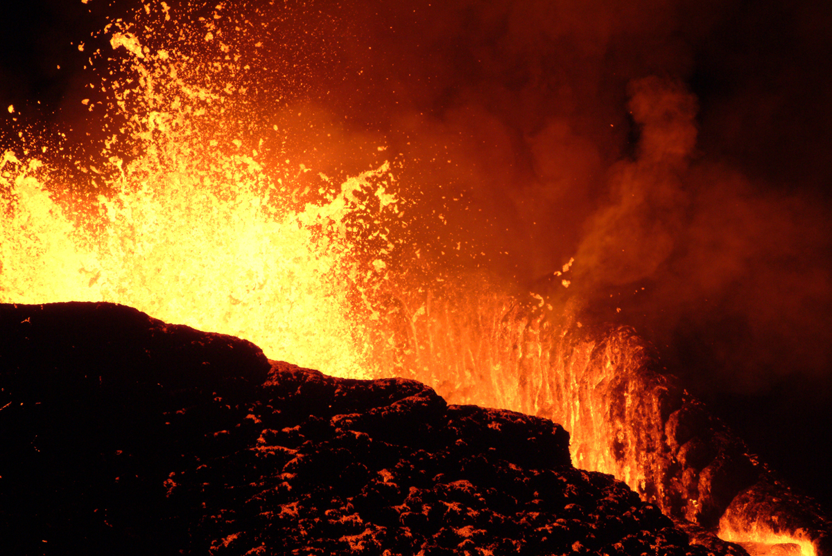
RADARSAT-2 imagery was provided after the International Charter "Space and Major Disasters
" was activated in response to an earthquake and eruption of Kīlauea Volcano in the United States in .
The International Charter "Space and Major Disasters
" is a collaborative effort for the benefit of those in need when disasters strike. It provides a unified system of satellite data acquisition and delivery to communities affected by natural or man-made disasters. With 17 Charter members and 61 contributing satellites from around the world, the Charter allows for resources and expertise to be organized for a quick response to catastrophic events. Member space agencies cooperate on a voluntary basis, with no exchange of funds, and each agency has devoted resources to support the Charter. Operating 24 hours a day, 7 days a week and at no cost to the user, the Charter mobilizes international partners, helping alleviate the effects of disasters on human life and property.
Did you know?
- Initiated by the European Space Agency (ESA) and the Centre national d’études spatiales (CNES) in , the Charter was signed by the Canadian Space Agency (CSA) in , making Canada a founding member.
- The Charter came into effect on . From that date to , there were 631 activations in 126 countries, including 14 activations in Canada.
RADARSAT satellites
What are they used for?
Following a Charter activation, members make satellite images of affected areas available to support relief efforts. The imagery of RADARSAT-2, and increasingly that of the RADARSAT Constellation Mission (RCM), provides support to search and rescue teams on the ground. Timely, reliable and accurate information enables response teams to be better equipped to save lives and limit damage.
In spring , snowmelt and rain caused flooding in parts of the Canadian provinces of Manitoba, Ontario, Quebec and New Brunswick. According to Statistics Canada, about 17,500 homes were either hit by flooding or considered to be at risk. Approximately 460 km of roadways were washed out and over 600 square km of land were flooded, including 153 square km of agricultural land. In Quebec, around 9,500 people were evacuated from their homes, while one person died in a flood-related road accident. Over 2,000 soldiers were deployed to the affected areas to help fill and distribute sandbags and assist residents.
Public Safety Canada, the Authorized User of the Charter for Canada, activated the Charter on . Two hundred and twenty-seven satellite products were provided by eight agencies. Natural Resources Canada produced 13 maps to support relief efforts.
Responding to a natural disaster
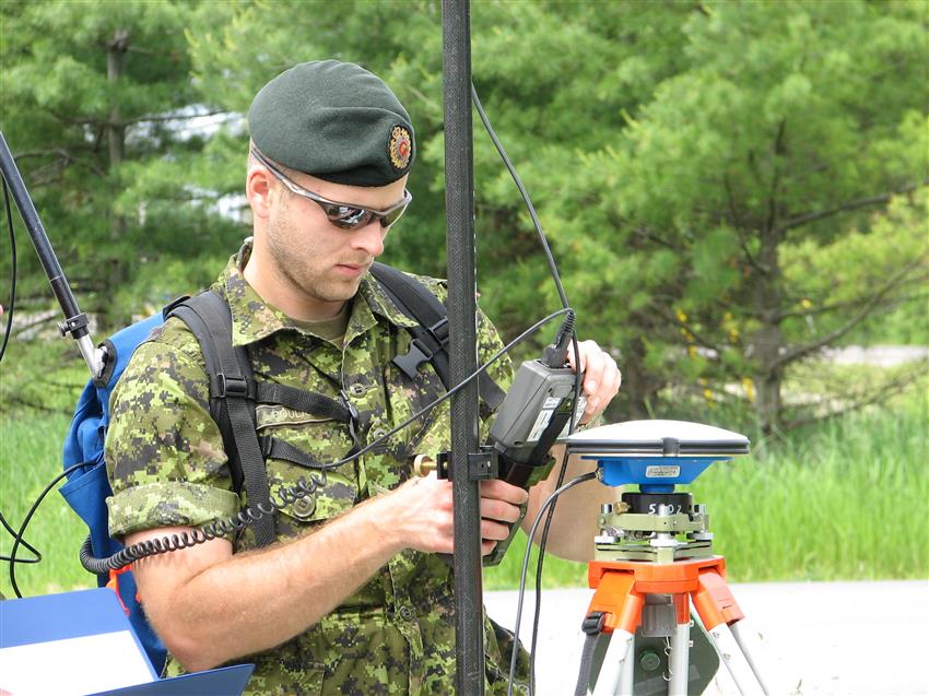
Credit: Marc Pouliot
Warrant Officer (WO) Marc Pouliot is the Chief of Geomatics for the province of Quebec within the Canadian Armed Forces (CAF). WO Pouliot is a first responder, meaning he is one of the first people to report to the scene of a natural disaster. In that role, he is responsible for rapidly taking stock of the damage in order to provide CAF decision makers on the ground with the appropriate advice. That is what he did during the floods in spring in the Montreal area, where his team was given the emergency task of analyzing and tracking the floods. WO Pouliot uses RADARSAT-2 data, to which he has 24/7 access, so that he can do his job with precision. RADARSAT data enables him to respond in a fast and effective manner in order to help Canadians in distress. Read WO Pouliot's full story.
To enable timely search and rescue

Cospas-Sarsat facilitates quick detection and rescue.
When it comes to search and rescue operations, time is truly of the essence. The less time ground crews take to locate and get to those who require assistance, the better the chances of survival. Satellites are indispensable for helping reduce this time. The International Cospas-Sarsat Programme is a satellite-based search and rescue system that supports the detection of emergency beacon signals in order to locate aircraft, ships and backcountry hikers in distress. The Programme's goal is to provide timely and reliable alert and location data to help local search and rescue authorities get to those in need as soon as possible.
The Programme's participants operate a satellite system that detects distress alert transmissions from special radio beacons, allowing to determine their position anywhere in the world. That information is then communicated to local search and rescue authorities.
Did you know?
- Cospas-Sarsat was initiated in and formally founded as an intergovernmental organization in by Canada, France, the United States, and the former Soviet Union (later replaced by the Russian Federation).
- Today, 40 states and 2 organizations are formally associated with the Programme and actively participate in its management and operation. Canada is represented by the National Search and Rescue Secretariat (NSS), part of Public Safety Canada.
- There are about 2,000,000 distress beacons worldwide.
- From to , Cospas-Sarsat helped rescue at least 43,807 people in 12,664 search and rescue events.

YouTube video - Cospas-Sarsat helps save lives. (Credit: International Cospas-Sarsat Programme)
Our satellites at your service
- Guiding rescue efforts from space
- The International Charter "
Space and Major Disasters
" presented with prestigious award - Saving lives when disasters strike