
How satellites help you stay healthy

Good health is a vital element of an active and fulfilling life. Our state of health depends on a variety of factors, including our genetics, diet, lifestyle, age, and access to medical care. Environmental conditions also play a significant role, and we can learn more about them through data produced by Earth observation (EO) satellites.
Health care is evolving rapidly to meet the changing needs of an aging population and advances in health technologies. EO satellites and space science play an active role in improving the health of Canadians and reducing health inequities.
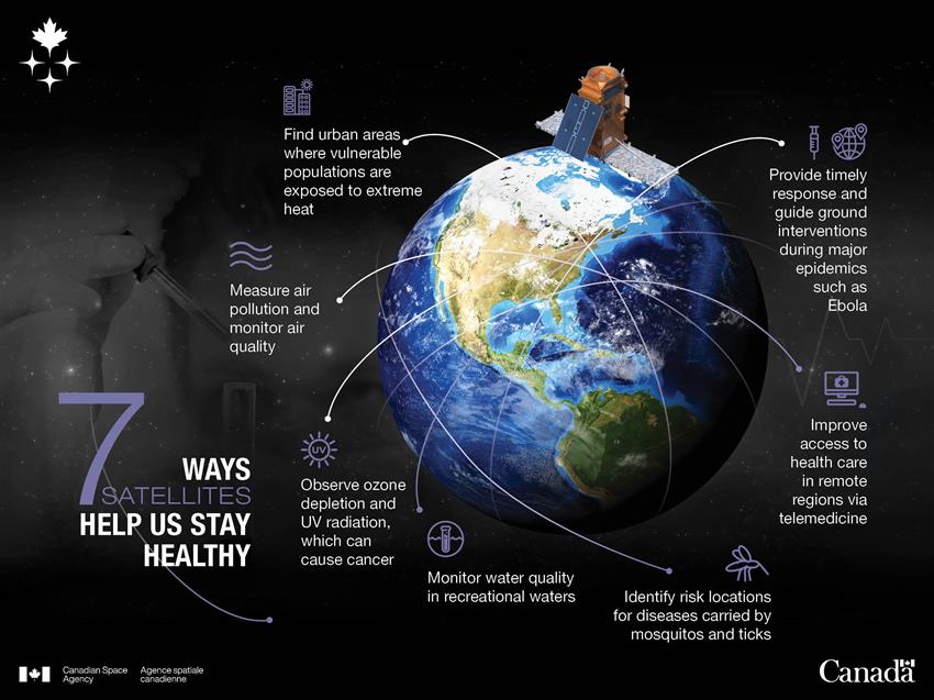
Text version - of infographic 7 ways satellites help us stay healthy
Credit: Canadian Space Agency
Which satellites provide data that can be used for public health purposes?
- RADARSAT Constellation Mission and RADARSAT-2: To monitor our environment (land, waters) and support the development of information on risk factors associated with environmentally linked infectious diseases, such as Lyme disease and West Nile virus; water contamination, such as infection by E. coli from recreational waters; and chronic conditions, such as cardiorespiratory disorders.
- RADARSAT-1: In operation from to , the Canadian EO satellite provided thousands of images, which can still be used by public health authorities to find out about environmental conditions during those years.
- SCISAT: To provide measurements of chemicals that affect the ozone layer, which protects us from the Sun's ultraviolet radiation.
- MOPITT (on Terra): To gather long-term data on carbon monoxide concentrations in the atmosphere, which affects air quality.
- OSIRIS (on Odin): To measure concentrations of ozone and air pollutants like aerosols, which can be produced as a result of volcanic activity.
- SMOS: To measure ocean salinity and could be used to assess risk associated with bacterial contamination of water in large coastal ocean areas.
Why use satellites to help with public health?
Monitoring air pollution

Poor air quality has been deemed one of the five leading health risks globally. The United Nations (UN) World Health Organization estimates that 9 out of 10 people around the world breathe air containing high levels of pollutants. The sources of this pollution include power generation, industrial operations, residential heating and cooking, agriculture, forest fires, and traffic. Exposure is most common in densely populated areas where pollution is highly concentrated with little surrounding greenery to mitigate.
Long-term exposure to polluted air can lead to:
- shorter life expectancy
- respiratory infections
- chronic obstructive pulmonary disease
- strokes and heart attacks
- lung cancer
Satellites help experts:
- identify pollution sources and the movement of pollution across regions, countries, and continents
- monitor and study air quality on a nearly continuous basis
They can:
- gather data on carbon monoxide distribution
- monitor forest fires and resulting pollution
- detect oil spills
- locate areas contaminated by mining activities
- contribute to daily values of the Air Quality Health Index
MOPITT on Terra
What is it used for?
Canada's MOPITT instrument aboard NASA's Terra satellite scans Earth's atmosphere to gather data on concentrations of carbon monoxide, an air pollutant toxic to humans.
These data are used to measure air pollution and the movement of pollution across regions, countries, and continents, and assess anti-pollution initiatives such as vehicle emission reduction standards. These data also help us understand the impact of wildfires and human activities, such as the combustion of biomass, and are utilized by the European Copernicus Atmosphere Monitoring Service to provide daily forecasts of global air pollution. During the 2015 Polar Aircraft Campaign over the Canadian Arctic, researchers from Environment and Climate Change Canada and Canadian universities used these forecasts to direct aircraft trajectories to study regional atmospheric conditions.
OSIRIS on Odin
What is it used for?
The OSIRIS instrument, on board the Swedish Odin satellite, measures ozone, aerosols, and nitrogen dioxide.
OSIRIS data help scientists better understand the impact of human activities and natural phenomena on the environment and climate. These data are used by Environment and Climate Change Canada scientists to study air quality, and they play a key role in international programs and organizations in which Canada participates, such as the European Space Agency's Climate Change Initiative, the Intergovernmental Panel on Climate Change, and the UN World Meteorological Organization.
Canada's OSIRIS instrument collects valuable information on the ozone layer that shields life on Earth from most of the Sun's harmful ultraviolet rays. It also detects aerosols and nitrogen dioxide in the atmosphere. (Credits: Canadian Space Agency, University of Saskatchewan)
Did you know?
Since farming and urban activities can significantly contribute to microbial contamination of recreational waters, the Public Health Agency of Canada uses data from various Earth observation satellites, including RADARSAT-2 and the RADARSAT Constellation Mission (RCM), to study the environmental characteristics of areas near beaches. This information could allow specialists to monitor water quality in a targeted manner in order to protect public health.
Observing ozone depletion and UV radiation
In Earth's stratosphere, the ozone layer acts as a blanket protecting life on Earth from harmful solar ultraviolet (UV) radiation. Ozone depletion, or thinning of the ozone layer, has become an increasingly critical global issue after its discovery several decades ago, with human activity being the primary driver.
According to the UN Environment Programme's Ozone Secretariat, ozone depletion and the resulting increase in UV radiation can lead to:
- cataracts, loss of vision (macular degeneration), eye cancer and cancer of the eyelid
- increased frequency of sunburns, photoaging, skin conditions and skin cancer
- reduction of immune system function and increased occurrence of infectious and autoimmune diseases
SCISAT
What is it used for?
SCISAT measures more than 60 different atmospheric trace gases, including ozone and ozone-depleting substances, in order to more effectively monitor changes in ozone-depleting substances and consequently UV radiation. SCISAT data contribute to the development of international environmental policies to protect the ozone layer, such as the UN Montreal Protocol, which bans certain chlorofluorocarbons and other ozone-depleting substances.
OSIRIS on Odin
What is it used for?
The OSIRIS instrument, on board the Swedish Odin satellite, measures ozone, aerosols, and nitrogen dioxide.
The data help scientists better understand the impact of human activities and natural phenomena on the environment and climate. OSIRIS has been providing daily, monthly, and annual measurements of the ozone layer since 2001, providing accurate data for researchers to monitor trends in ozone depletion and the resulting increase in UV radiation.
Identifying and monitoring risk locations for mosquito- and tick-borne diseases

In addition to being a nuisance that can ruin outdoor activities, mosquitos and ticks can carry dangerous diseases, such as West Nile virus and Lyme disease respectively. While satellites cannot see mosquitos and ticks from space, they can help identify and monitor areas at risk for mosquito- and tick-borne diseases. To thrive and reproduce, mosquitos and ticks require certain environmental conditions, including specific micro-climates, soil and vegetation. Satellite data can help identify the areas that meet those conditions and, consequently, are likely to harbour mosquitos and ticks. The satellite-based information is used by public health authorities and municipalities in order to inform the public about the risk areas.
RADARSAT satellites
What are they used for?
Data from RADARSAT-2 and the RADARSAT Constellation Mission (RCM), together with images from optical satellites, are used to characterize habitats with conditions favourable to mosquito and tick survival. By combining these data with on-site observations, dynamic high-resolution risk maps can be created. These maps can help the general public take special precautions when planning outdoor activities, as well as assist public health authorities in targeting surveillance efforts and developing prevention programs.
Improve your health: a team effort!
The Canadian Space Agency, together with researchers from the Public Health Agency of Canada, Environment and Climate Change Canada, Université du Québec à Montréal, Université de Montréal and the City of Montreal, has spearheaded the "Urban health indicators derived from Earth Observation data" project. The research team is investigating the use of Earth observation (EO) satellites to identify environmental health risks, specifically in urban areas. The project aims to use RADARSAT-2 data, along with information from other EO sensors, various databases and field data, to help find areas where vulnerable populations would be exposed to extreme heat, air pollution or infectious diseases transmitted by mosquitoes. These diverse datasets will then be integrated into a single database for public health agencies so that prevention and control measures can be put in place. While the approach is being developed in Montreal, once it is proven to be effective, it could be applied in other Canadian cities.
Improving access to essential health services
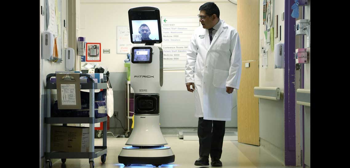
Credit: University of Saskatchewan Remote Medicine Robotics Program
Advances in space technology and telecommunications services have led to state-of-the-art systems and applications that are revolutionizing public health services, particularly for those living in remote and isolated locations.
- eHealth refers to information and communications technologies like information and patient monitoring systems that improve the quality, accessibility and efficiency of Canada's health care system.
- Telehealth includes the use of communications technologies like videoconferencing services to give specialist advice and health education to health care providers, particularly those in remote locations.
- Telemedicine applications like tele-operated surgical systems now exist thanks to innovations in both satellite communications and robotic technology developed for Canadarm.
Satellite data: a critical tool in responding to pandemics
Public health authorities are using various data, including data from EO satellites, to guide ground interventions during major epidemics such as Ebola. Information derived from EO can be used by field epidemiologists and medical staff to locate roads and infrastructure, to support the deployment of services such as temporary hospitals or mobile laboratories, and to support the investigation and surveillance of diseases and the development of databases. Also, information derived from EO can be used by medical geographers and epidemiologists to support the monitoring and understanding of human disease. Satellite data is an important tool for preparedness and timely response to pandemics.
Our satellites at your service
- Using satellites to identify potential health risks in cities
- Monitoring the impact of British Columbia wildfires from space
Helpful public health links
Explore further
- Date modified: